2009-05-22 40 -4
From Geohashing

| Fri 22 May 2009 in 40,-4: 40.4905859, -4.3600474 geohashing.info google osm bing/os kml crox |
Participants
Plans
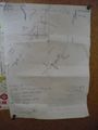
Who doesn't like plans?
- Realized yesterday that my meeting would end in the early afternoon
- Rented a car for the weekend
- Asked the maitre d' which hash would be recommended for people without a GPS device.
- Then decided that since yesterdays hash had been too easy, there would have to be a challenge
- Segovia, Spain not only had an interesting terrain profile (I like mountains), but also the hash in a deserted (I meant devoid of structures at that time) forest, where I would have to identify the correct lump of trees based on the satellite images.
- Hence the plan. I indicated all the sandy tracks I could make out, and any other landmark. Landmarks would be mostly significant bends in these tracks. In the close range, landmarks were large trees, casting a significant amount of shadow on the tracks.
- Failsafe, eh?
Expedition
- Meeting ended even earlier than expected.. I had reserved the car for 4pm and turned up at 2pm.
- They gave me a Tomtom! Doh! Tomtoms have batteries! Double doh! If I had expected to get a mobile GPS device which I can take out of the car I would have written down the coordinates!
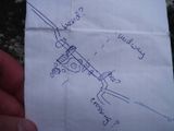
- But, as you can see on the plans, I hadn't. And so this would become a second no batteries hash, just as I had planned. Stick to the plans, I say. They are failsafe.
- Navigated to Valdemaqueda.
- Realized that I had just misspelled "El Hoyo de Pinares" (roughly translating as: today's special: conifer forests), and asked tomtom to navigate me in that general direction.
- Confirmed my assumption that the district border would be signposted.
- Counted left and right bends from that sign on.
- Identified the right dirt track to turn into.
- The entrance was not gated, but there was an almost unreadable sign next to it. I got out, deciphered it as "Private Hunting Ground", and took this for an excuse to walk instead of taking the car all the way. I realized on my way back that basically all pieces of land in that area were either posted as the above, or as "State controlled hunting ground". I gather that this only intends to control poaching, and probably does not forbid you to use the tracks.
- There was a nasty cattle grid at the gate: The bars that constituted the grid would roll freely along the frame when you step on them. That would allow a human foot to be caught just as well.
- I met a woodworker, and asked if it was ok to take a walk here. He confirmed. (As he probably only worked in the forest and didn't own it, I guess that's not a particular achievement)
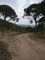
- I followed the sandy tracks.. it was hot (29°C today), sunny, dry.. oh, should I have taken some water? A hat? Well, next time.
- The forest smelled nicely, the way only dry pine forests can.
- I have uploaded most photos in the tracklog, and will only occasionally link to the others from here.
- There was no trouble to identify the significant bends in the tracks during the first part of the expedition
- I identified both tire and hoof tracks. There must have been a horse driving a car. A Flintstones model T probably.
- Some houses were occasionally hidden behind the trees in the distance.. but I did not meet anyone.
- There were interesting rocks.. rose.. quartz?
- I reached a hacienda next to the road. On my close-up map, I had identified a white line next to the track that might possibly be a piece of track leading to nowhere. I was quite sure to have found it right in front of it. However, that would have meant that the hash itself lay in its barbed-wire-fenced backyard. What the duck?
- I therefore decided to continue along the track until the next crossing, so that I could be sure to have passed the right place.. I mean, I still could have misjudged the distances. (I freely shortened "straight" portions of track on the map with a --//-- symbol.)
- The crossing wouldn't come.
- But what came was another piece of track, to the left, dissolving soon after in the needly ground. Yay!
- From there on, I was to counting trees again. And identify what could possibly that dark spot between the hash and the next tree.
- I identified a rock field that would present a possible option for a dark smear on the photo.
- Walking to the southern corner, I set up my stupid grin and declared this the geohash.
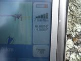
- At this point, I took out the tomtom, and took a photo of the coordinates, to be later confirmed when I were back at home.
- Do the math yourself.. I'm not good at it. I estimated from the google distance calculator that I have been within the 20m range. (Which I consider awesome. Just look at the blurry satellite picture.) And since there were no significant obstacles anywhere, I call it a success.
- I took note that the tomtom battery is continually flat.. should I go hashing during the next days, it will have to be a no batteries, confirm coordinates on location approach.
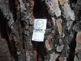
- I left my card
- Can somebody tell me what this is? It's a box, suspended from a tree. It has a slit on the bottom, and a funnel-shaped hole in the side. A bird house? A bird trap? A geocache? :D
- graffiti made the hacienda look all the more deserted
- a very distant satellite dish - Oh, must be this one!
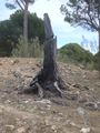
- Did I mention that the wood was dry? I could imagine that this tree spontaneously combusted and turned into that stump within mere seconds.
- They have some huge pine cones here - Unfortunately, they were all empty.. I love pine seeds.
- I have a knack for machines that can pull. This stood next to the place where the woodworker loaded a truck with lumber.]
- Other people have also realized that the forest is dry.
Tracklog *with* Photos
(but it's not a real tracklog)
http://www.everytrail.com/view_trip.php?trip_id=216084
Gallery
plans?
I was to counting trees again
Do the math yourself
I left my card
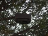
Can somebody tell me what this is?
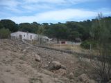
graffiti made the hacienda look all the more deserted
a very distant satellite dish
Did I mention that the wood was dry?
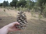
They have some huge pine cones here
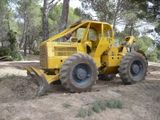
I have a knack for machines that can pull.
Other people have also realized


