2009-05-31 -36 142
| Sun 31 May 2009 in -36,142: -36.9138364, 142.5325219 geohashing.info google osm bing/os kml crox |
Contents
[hide]The location
In a paddock just off the Western Highway, in the area of Dadswell Bridge.
Who Went?
myka
Day 2 of driving for the weekend. Like Yesterday, my normal day of traveling would take me through some 6 Graticules. 3 Hashes are within reasonable distance of my route. This is the First.
(report written en-route, and therefore has possibly confused tenses)
Bendigo To the Grampians
The day started with a drive from Bendigo to the very norther tip of the Grampians National Park. Since I was driving my dad out (he was to drive a bus back to Bendigo), I did not try for the Hash points on the Outbound trip.
It was a pleasant drive out, light on traffic (not that there ever is much on this trip) and uneventful. The last section, from Stawell to the pickup point, had some particularly nice views across to the Grampians.
After Hitching up the Trailer I was driving home, and taking a break to make sure I wasn't too tired after already driving for 3 hours, I was ready to go.
Dadswells Bridge
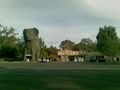
Dadswells bridge is a locality distinguished by having a Big Koala. (last night in the dark I found out it was an Big Evil Koala, with glowing red eyes!).
The hash was located a few hundred meters from the Western Highway (A major highway, and the main one heading West from Melbourne towards Adelaide, the Nullarbor, and eventually, Perth). Once more in a paddock, this should not be an excessively hard point to reach.
Driving towards Dadswells Bridge (which doesn't seem to have a bridge at all, as far as I can tell) brought me a wildlife encounter. Four Emus foraging beside the Western Highway. I pulled over to take a photo, but while they seemed quite content to have cars drive past at a High speed, as soon as I started to walk in their direction (still on the opposite side of the road) the Emus scampered off into the forest. I know there are plenty of them in the National Park, but it is not so usual to see them so close to cars.
I drove down a nice little dirt road, dodging large puddles of standing water (also unusual these days), and parked by the paddock the hash was in.
The standing water was interesting, there was plenty of it, and it had not been there yesterday as I was driving in the same area, meaning of course, that it had rained late last night or early this morning.
I walked the ~750m across the paddock to the hash point. Luckily, the direct path took me away from any groups of sheep, which I would prefer not to disturb if possible. There was a farmhouse in the next paddock (beside the highway) but no signs of activity.
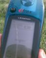
For once, I did not even have to do a GPS dance. I walked steadily to the point where my GPS said there was less than a metre to the Hash, and stopped. The GPS promptly settled on 0.76m distance from the hash, and stayed there for a couple of minutes as I took a photo of both possibly Fergus and the Proof. I would have thought it was broken if it hadn't begun tracking my movements again as I walked back to the car.
I then headed onwards towards Natte Yallock
myka earned the Multihash Achievement
|
mykaDragonBlue earned the Graticule Unlocked Achievement
|
Photos
myka
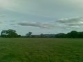
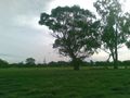
The Hash-paddock, with the Grampians in the background.
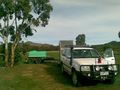
Picking Up the trailer just north of The Grampains.
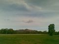
Hollow Mountain, as seen from the trailer Pickup.
There were Emus here moments ago.
Dadswells Bridge ... Big (Evil) Koala.
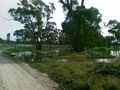
Standing water... odd in a drought.
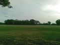
the Hash Paddock

an accurate GPS
blurry but readable Proof.
The Hashpoint.
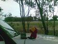
hashing paraphernalia.
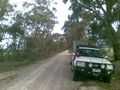
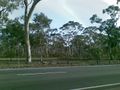
These country lanes are kinda fun.


