2009-06-24 49 9
| Wed 24 Jun 2009 in Würzburg: 49.7281007, 9.9799548 geohashing.info google osm bing/os kml crox |
Location
Today's location is next to the track in a forest near Würzburg-Rottenbauer.
Country: Germany; state: Bayern (Bavaria, EU:DE:BY); administrative region: Unterfranken; district: Würzburg rural district
Weather (18:00): mostly clouded, 21°C
Expedition
Srs0
It was overcast when Srs0 caught the tram from the Rathaus stop and took it to Rottenbauer (the last stop for the tram). He then got off and walked the remaining ~2.5km to the geohash. Due to the simplicity of the path he took, he never ended up needing to look at the instructions he had written down before hand. At around 17:40 he arrived at the hashpoint and stood around for a bit, pretending to take pictures when people walked by. Well, that's not entirely true, as he was taking pictures for the first bit, but the later ones were faked.
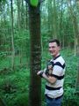
At around 18:00, Danatar arrived on his bike. They used his speedometer to determine a more accurate location for the hashpoint, and srs0's guess ended up being around 5 meters off. Danatar marked a tree, took some pictures with his hash-hog, and they talked a bit. At around 18:15, they once again parted ways and headed home.
While they were in the forest, the sun had come out from behind the clouds. He walked slowly back to the Rottenbauer train stop, taking lots of pictures as he went. As he neared the station, the clouds again took over the sky. The rest of the trip back was uneventful.
An interesting note: this is the first geohash that srs0 has done without thepiguy.
Danatar
Danatar took the usual cycle track until Heidingsfeld, but then he came onto unknown terrain. The track along the Main was made from cobblestones for part of the way and thus not easy to use with a bike, so he stayed on the main road. From the city limit of Heidingsfeld Danatar took a track along the railway until he reached the last intersection before the hashpoint. The last few hundred meters were very steep and when he arrived at the hashpoint he was really exhausted. Srs0 was already waiting at the hashpoint. Danatar marked one of the trees next to the track with chalk, they talked a bit, then parted. On the way home, Danatar tried to find a better cycle track, but without success.
Total distance by bike: 12.9 km *2 = 25.8 km, 80 m uphill
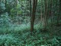
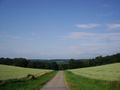
A view of the area by the hashpoint.
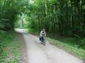
Danatar biking up the last part of the hill.
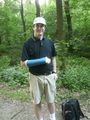
Srs0 waiting.
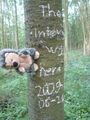
Danatar preparing to mark the tree with chalk at the hashpoint.
Danatar and his chalked tree.
Hedgescot the Hashhog (name not totally fixed yet)
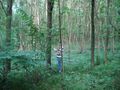
A view up the path from the geohash. Taken as srs0 was leaving.
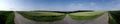
The same location as the previous picture, but a panorama!
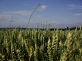
A close-up of the field to the right in the panorama.

The sun went behind a cloud as srs0 neared Rottenbauer on the way home.
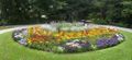
Flowers in the Ringpark in Würzburg.


