2009-07-02 48 12
| Thu 2 Jul 2009 in Landshut, Germany: 48.9368706, 12.1279524 geohashing.info google osm bing/os kml crox |
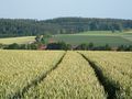
In a field south of the former military training range of Oberhinkofen.
dawidi with Tomcat
We met at a busy intersection in the southeast of Regensburg after work and cycled to Oberhinkofen, rather unintentionally going the shortest route, which meant sharing a country road with fast cars and motorcycles.
Locating the hash field was no problem, but it was of course filled with green spelt crops and seemed inaccessible. We took a few pictures from the track, then went around the field and found several tractor tracks leading into the field, just wide enough for a person to walk in without harming any crops.
Tomcat stayed out of the field, but I picked one of the tractor tracks and went in. The track got me to within 4m from the coordinates, which I decided was good enough. I took another panorama from there and waded out of the field again.
For the way home, we used a different route via Bad Abbach, which allowed us to eat dinner in an Asian restaurant in Oberndorf. We returned to Regensburg on the familiar cycleway along the Danube, arriving just after 22:30.

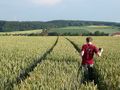
Dawidi wades into the field...
... and stops at the hash.
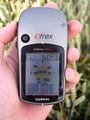
Coordinates reached!


Among spelt.
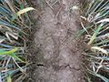
The ground near the hashpoint.

Back in Prüfening after dark.


