2009-07-14 49 11
| Tue 14 Jul 2009 in Nürnberg, Germany: 49.1064036, 11.9918096 geohashing.info google osm bing/os kml crox |
In a chunk of dense brush within a large forest just east of Wolfsegg, about 15km northwest of Regensburg.
dawidi with Tomcat
I was planning to do a Tron expedition and had taken some detours on my way to work already in order not to cross my own path.
We met in Kneiting 18:00, and cycled north on the usual cycleway through Reifenthal and Schwetzendorf heading for Baiern. While we were going up a small hill, there was a sudden cracking sound - I looked back and saw the chain slip off Tomcat's bike. It had come apart at one of the rivets, and while we had a few bike repair tools with us, we had nothing to put the chain back together.
Immediately, Tomcat announced I'd have to go to the hash alone, and he would be coasting downhill (about to where we met) and then be pushing his bike back home (about 6km more, mostly uphill). I wondered, though... his bike has an electric auxiliary motor which, due to legal restrictions, only works as long as he is pedaling too... but the sensor is mounted to the crank... "Couldn't you just pedal idly and use the motor?" - "I... think so, yes... oh hey, and both battery packs are still full. That should be enough to get to the hash and back."
And indeed it worked - so instead of splitting up, we continued together as planned. Except that now Tomcat was going uphill at 20kph pedaling idly and I had an even harder time keeping up with him than usual - and sweating quite a bit at 26°C with high humidity...
We stopped at a slip road 30m from the coordinates, and Tomcat went to look for the exact position. After he had found it, I carried my bike into the brush in a wide loop, set it down at the hashpoint (or as close as I could expect to get with bad GPS reception), took a panorama, and carried it out onto the road again without crosssing my own tracklog. We stood by the roadside for a few minutes, planning the return route while I took another panorama.
Across minor roads and some more-or-less drivable forest tracks, we made it to Pettendorf, and from there to Adlersberg, where we turned west instead of going down into the valley (so I could avoid my tracks). At the next crossing, we had to decide between an unpaved road into the Naab valley, which would have been an easy, but slightly longer route; a series of field tracks that I knew lead to Mariaort; and following the main road which lead down to Kneiting where I would have to cross my tracks... but on Tomcat's GPS, there was a track off the main road just before it met with our tracks, and leading to Kneiting without crossing them. My GPS didn't show that track; still, we decided to use that route.
As we got to the place where that track should have started, it dawned on us - that track was on the infamous Garmin topo map (i.e. from a survey at least 15 years ago). It had since been abandoned, and was now covered by a field and a new house, which is why it was "missing" on OSM. Since I had been cycling on the far right, I could not go back and take a right turn without voiding my Tron achievement, and would inevitably crash into my tracklog at the next crossing if I kept going.
Cue sounds of "aaaaagghhh!", *thud*, synthesizer bubbling and a sharp *shinnng*. ... oh well. I'll have to try again.
Arriving in Mariaort at about 21:00, Tomcat still had a good (nonlinear) "80%" of charge left in his second battery pack, and we were kinda hungry, so we ended this nice little evening tour in the pizzeria around the corner from my place, and around 23:00 we split up and Tomcat tried to get all the way uphill to his home on the remaining charge. (I wonder if he managed to do that, or whether he had to push?)
- My bike did its unintended job very well and carried me uphill the final 4km to my home without any assistance provided by its rider :D Tomcat 09:11, 15 July 2009 (UTC)
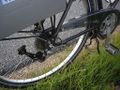
Tomcat's bike, unchained.

Screenshot from Tomcat's GPS
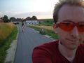
Cycling home (near Hinterberg)


Tomcat earned the Plan B achievement
|