2009-07-25 49 9
| Sat 25 Jul 2009 in Würzburg: 49.8168510, 9.9049259 geohashing.info google osm bing/os kml crox |
Location
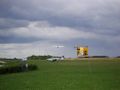
Today's location is near the airfield Am Schenkenturm at Würzburg-Unterdürrbach
Country: Germany; state: Bayern (Bavaria, EU:DE:BY); administrative region: Unterfranken; district: Würzburg city
Weather: sunny, clouds, windy
Expedition
thepiguy and srs0
When thepiguy and srs0 left their house for their first walk geohash, they were only 2.5km from the coordinates! One hour and 5km later, they were still 2.5km from the coordinates; the only difference being they were now on a bridge across the river they'd been stuck following. Darn Main! As per usual, thepiguy pulled out his gps and began trying to plot a course to the coordinates, while his fellow geohasher (srs0 this time) suggested they follow the large sign pointing to the airport. They were almost at when they saw a suspicious figure walking towards them.
Danatar
Danatar didn't feel good enough to do a walk or bicycle geohash, so he took the car and drove to the airfield. He parked the car farer from the hashpoint than planned because he misinterpreted a sign. When Danatar started to walk towards the hashpoint he could see two suspicious figures in the distance. Not much later he encountered srs0 and thepiguy waiting at the next intersection and they continued towards the hashpoint. The meadow next to them was lined with no trespassing signs because of the nearby military shooting range and they feared they might not be able to reach the hashpoint. When they arrived next to the hashpoint, these signs were only on one side of the road. On the side with the hashpoint there were only signs a bit further off, at the edge of the forest where also the hashpoint was, warning of dud ammunition. So they were technically allowed to take the last steps to the hashpoint. Still srs0 and Danatar let thepiguy go alone to get a picture of his GPS device while they hoped that any mine's blast radius was small enough to spare them.
After that they went to the medieval Schenkenturm tower, but the door to the tower was locked and they weren't able to climb it. They watched planes take off instead, then they started on their way back. Danatar took the car while thepiguy and srs0 decided to try another route on their way back, since they hadn't got lost yet.
thepiguy and srs0 (again)
They took a different path home, and ended up getting semi-lost at one point. They may have made it all the way to the geohash with no troubles, but the gps was needed to get back home. Admittedly, they could have just walked back to the same bridge and had no problems, but they wanted to take a different way home.
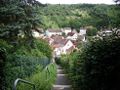
They set off along a small road and followed it to where a sign was proclaiming there was a dead end. Thepiguy refused to believe it, due to his gps telling him otherwise, and sure enough there was a narrow path with lots of stairs going into the valley. Upon reaching the bottom, thepiguy and srs0 went up and down one street a few times, semi-lost, before the gps told them where to go. They ended up going up another narrow path with stairs on the other side of the valley and then followed another small road to the top of the hill. There, they could see the majority of Würzburg laid out below them, and they stopped to take pictures. From there it was a simple task of following the path down the hill and back home through the city.
Danatar's gallery


Srs0 and thepiguy's gallery

Playing around on the walk out.

A sign pointing to the Flugplatz.
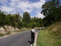
Walking along a road.
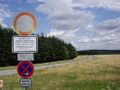
The military is warning us to stay away.
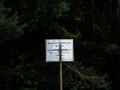
Again, the military warns us.
The hashpoint is near.

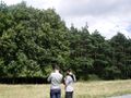
Geohasher #1/3 with his hashhog.

Geohasher #2/3 enjoying his Nibs.

The "airport"!
A plane flying away.
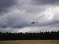
A plane landing.
The gps was right, it wasn't a dead end!

The bottom of the same stairway.

Going up!

Looking over the Zellerau portion of Würzburg.

Steep hill!


