2009-08-10 48 8
| Mon 10 Aug 2009 in 48,8: 48.8559601, 8.4619887 geohashing.info google osm bing/os kml crox |
Location
In the Weinbrünnlestraße in Pfaffenrot, a part of the municipality of Marxzell, located in the Black Forest, population 5,385. Next train station is the station Marxzell on the Albtalbahn, line S1.
Participants
Plans
As the hashpoint might or might not be inside a house, thus no public access, I decided to simply go there by day, taking the S1. There's also a bus from the station to Pfaffenrot, but it has a terrible connection to the train, so I'll probably walk.
If the Hashpoint would have been clearly accessible, I also had plans for a sunrise geohash or an extremely elaborate tron geohash via Durlach and Ittersbach, but since it seemed not-accessible, I didn't want to try.
My S1 is leaving from Karlsruhe Ettlinger Tor at 14:12 (connectihg from a re-routed S5 from Durlacher Tor at 14:05), arrives in Marxzell at 14:46.
Expedition by Koepfel
Report
To reach the Albtalbahn, I had to get to the Karlsruhe inner city. However, the tram line between Durlacher Tor and Marktplatz, which I had to take from my home, is currently being renovated, resulting in various rerouted tram lines in the inner city. Since the renovations started just today and I didn't know what to expect, I took an earlier tram, a rerouted S4 to Karlsruhe Albtalbahnhof. There, I just missed the previous S1 to bad Herrenalb and had to wait about 20 minutes for the next one, the one I originally intended to take.
The stop is called Albtalbahnhof, since the Albtalbahn (Alb valley Railway, the line to Bad Herrenalb and ittersbach) starts here. The Albtalbahn used to be a narrow gauge railway, but was regauged and integrated into the Karlsruhe tram system as a light rail in the 60s. Finially, at 14:27, my slightly delayed S1 arrived, which brought my to Marxzell by 14:53.
As mentioned before, the bus connection to Pfaffenrot is rather bad, sp I started walking. After a few meters, I came upon thiscar from the former tramway of Pforzheim, stabled here for some kind of museum. Amongst some other tram cars, there also was this plane, a steam engine, several vinatge cars and Feldbahn(1) vehicles and other stuff, but sadly, the museum seemed closed.
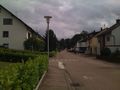
I was walking along the L565, upwards, when I noticed the path I was actually looking for, the Hirschweg was running parallel to me, but on a higher level. No connecting trail seemed to come up. Turn around? Nah, Geohashers don't turn around. Straight through the forest we go! I kept on walking on some forest paths, which's condition became worse every steo, but I eventually spotted signs of civilisated life! Arriving in Pfaffenrot.
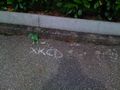
From there, it was just a short walk to Hash Road, the Weinbrünnlesraße. And now, the GPS-dance begins. I had trouble finding a strong GPS signal, so watched by curious residents, I tried to find the spot. The GPS zeroed in while holding it over a hedge, from the public road, so coordinates reached. Since I was running out of chalk, I decided to just write "XKCD" (instead of the usual, more detailed marker with coordinates).
For the way back, I saw, that a bus was set to go at 15:57, so I left the Hashpoint and walked to the bus stop "Carl-Benz-Schule" at the main road. The Carl Benz School was nearby, probably the only reason a bus goes up here. As school children have no school these days (summer break), I was the only passenger in the bus to Marxzell. At the Marxzell station, I took the S1, departing at 16:13, back to Karlsruhe, where, after struggling with the rerouted tram lines for a while, I arrived at about 17:00.
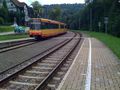
Stadtbahn in Marxzell
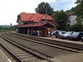
station of Marxzell
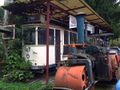
Tram car from Freiburg at a museum in Marxzell
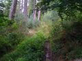
Yes, this is a path.
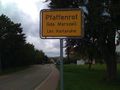
Town sign of Pfaffenrot
Hash Point
Hash Road
Hash House


(1) A Feldbahn (lit field railway) is the German term for narrow gauge railways, used mainly for freight transportation e.g. in mines or for forestry, usually not for public operation. There seems to be no English term for that.