2009-08-15 48 9
| Sat 15 Aug 2009 in 48,9: 48.5997355, 9.2830193 geohashing.info google osm bing/os kml crox |
Contents
Location
Outside of Altdorf (Kreis Esslingen), although the actual spot is part of the municipality of Neckartailfingen. On a meadow, just at the forest margin.
Participants
Expedition
This is a story of downsizing plans to make them fit reality.
Friday afternoon I still tended to plan for a large all-day trip, choosing the most interesting coordinates from the available ones. Those were identified soon: Sankt Gallen graticule, a location in Switzerland, not far from the Lake Constance. The weather forecast convinced me not to do that, though - the area is totally overrun by tourists and wannabe-sunday-cyclists unable to go straight on the right side even if it is not school holidays, saturday, and sunny at the same time. On a day like this, you should mount an automatic bell to your bike. There's no need to switch it off anyway.
Given that the coordinates in my home graticule were reachable by bike and almost definitely accessible, the new plans were to go there for 4 pm, but take the longer and slower route via Reutlingen to hit a number of shops along the way.
However, in the morning there were a number of other things I wanted to get done, and general laziness, so around 12 it became rather unlikely that the shopping detours would be doable before 4 pm. So I dropped them. Going between 1 and 2 would allow to comfortably get to the hash on the fast route through the Neckar valley, and maybe stop two or three times for a geocache along the way.
Little before 2, I was ready to go, but got held up for another few minutes. Ten past two, I started. The timeline was getting ambitious. I got as far as 200m, then noticed that I had done something wrong with the last try to fix the bike. Turned around, picked up another tool, fixed it.
Started again at 14:28. Now the timeline had changed from ambitious to hardly possible. Nevertheless, it wasn't entirely impossible. I would have to keep up a speed that's close to my maximum, though... but, still worth a try, isn't it? The Neckar valley trail is a beaten path, good surface conditions almost all the way, no significant slopes. If there were a few less narrow 90-degree-turns, less sunday-cyclists and the dogs would do a better job pulling their leashed owners off the way, it would be really convenient.
I just kept racing, only stopping if really necessary, withstanding also the urge to stop for photos. I'm sure I'll go that way more often this year, so I can probably take them another time. Kept the speed above 30 km/h whereever possible. By the time I reached Neckartailfingen, the place where I had to leave the valley, the speedometer showed an average speed of 27 km/h - I don't think I ever saw such a high number before. Usually already the city traffic until reaching the town margin ruins the average for the rest of the trip.
I had guessed a probably useful way up into the hills on the map. The first part wasn't really convincing - OSM had shown a tracktype 2, which should be a gravel track in good condition. It actually was a almost unpaved tractor trail, a row of muddy puddles, more than ten cm deep. Anyway, it was kind of hot, so I didn't mind to get wet feet. And then it eventually led to a good, paved way up.
Finally I had made my way onto a hilltop, and got a first glance on the hash. From here it was about 300 m into a meadow and there seemed to be no further way. Anyway, the grass wasn't very high, so the meadow was even cyclable. And when I finally reached the hash, it was 9 minutes to four. I had made it.
There was someone mowing a meadow nearby, and I didn't really want to have to explain him what I was doing. So I just sat down in the shadow, placed the marker at a place where you only see it when getting really close, and waited for meetup time. As expected, nobody else showed up. A few minutes past four, I left and first went into the forest for a very close geocache - which I couldn't search because of a another farmer mowing the meadow.
Then I went into what I had believed was hash village, Altdorf (I later found that the actual point belongs to Neckartailfingen). One somehow funny thing was the name of the local carpenter whose house even is in the first row of houses when coming from the hash: He's called Hasch. Which actually is the german spelling of Hash (to be strict, not in the meaning of the mathematical concept as in that case the english word is used as a technical term). So, there really was a hash house near the hash ;-) Another fun fact: The road I used to enter the village was named Bahnhofstraße - station road, as in railway station. It actually led to a point at the railway line about 1.5 km outside the village. As far as I could find out, there never has been a station there, though. Did those villagers name the road in the hope that there would be a station built later? Or was the station in question actually the one of Neckartailfingen, about 3.5 km from the village?
Did a lot of more or less useless detours on the way back, this time even went via Reutlingen, but got there far too late for the shopping part. In the end, it wasn't the greatest of expeditions, but still a nice day.
Gallery
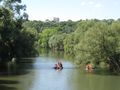
If those were hashing, they would qualify for the maker achievement.
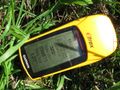
Coordinates reached
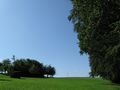
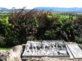
At the hash
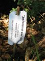
The standard marker
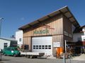
One of the closest buildings to the hash is the Hasch house.
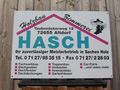
Yes, that is actually the german spelling of "hash".
You can't totally deny some similarity.
View from hash ;-)


Ekorren earned the Birthday Geohash Achievement
|