2009-09-04 50 10
| Fri 4 Sep 2009 in Gotha: 50.2206720, 10.5537864 geohashing.info google osm bing/os kml crox |
Location
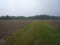
Today's location is at the edge of a wet and muddy field near "Sulzdorf an der Lederhecke" and Serrfeld.
Country: Germany; state: Bayern (Bavaria, EU:DE:BY); administrative region: Unterfranken; district: Rhön-Grabfeld (<200 m from the border to Hassberge district)
Weather: Rain. Heavy rain. More rain. A bit less rain. More rain again. Flooding. Rain.
Expedition (Danatar)
This hashpoint would usually be too far out of the way for me to even consider going there, but today I had no choice: It's my birthday and I wanted that birthday ribbon. After work I set out towards the hashpoint with the plan to first visit this hashpoint and then my displaced origin hashpoint for this graticule, which is only 4 kilometres (and 28 years) away.
In Stöckach the road to Neuses was blocked. Because of that I had to take a large detour and decided to go to my displaced origin first. It had been raining almost all day, but it was not very intense at that moment.
1981-09-04 50 10 retro expedition
I left the car at the edge of the forest where the forest track began and started to walk. After 100 metres I turned back for the piece of paper with the coordinates on it. I followed the track until I was just north of the hashpoint, then I went between the bushes until I reached the hashpoint. It didn't rain much under the trees, but the plants were very wet. After taking pictures I went back to the car and drove to Serrfeld. The rain got more intense.
2009-09-04 50 10
The journey in my blue space-and-time machine ended on a field track 300 metres from the hashpoint. The last part was only a dirt track and I didn't want to drive over that. With Scott hidden in my jacket, an umbrella on my shoulder, GPS and birthday cake in one hand, camera in the other I went to the target field. Standing on the grass directly at the edge of the field, the GPS showed 0.00012° more to go. With mud in front of me, and rain from above. I hadn't come that far only to turn back, so instead of invoking the "near enough and no obstacle in sight" rule I took some more steps. Mud, I already told that. Yuck! And I didn't have my worthless geohashing shoes on, but my good everyday shoes. I only snapped a picture of the GPS within accuracy distance of the hashpoint and went back onto dry non-muddy land. There I sang "happy birthday to me" and ate my cake. I quickly went back to the car and drove home. While I was driving there were some even stronger downpours so that sometimes I had trouble seeing the road in front of me.
Danatar earned the Birthday Geohash Achievement
|
Almost there
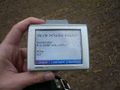
Coordinates reached

Birthday pie for Danatar


The gallery for the visit to the retro hashpoint is here
P.S.: This expedition consisted of a lot of "why am I doing this?" moments