2009-09-20 47 -121
| Sun 20 Sep 2009 in 47,-121: 47.7252738, -121.9625589 geohashing.info google osm bing/os kml crox |
Contents
Location
Near a back yard fence in Duvall, Washington.
Participants
Expedition
Robyn was on her way back from the Seattle-Tacoma airport, which she has just remembered was the opposite of her excuse for the 2009-09-10 47 -122 geohash, and decided it was worth a diversion to the east to see if this geohash was accessible. There was the usual amount of driving along winding western Washington roads, trying to find the turnoff matching the one shown on Google Maps and then parking on a residential street and walking back to see if the spot could be reached without trespassing.
At first it looked simple, with an opening in a fence right where the GPS pointed, but it wasn't a park or a public path, just some homeowners with a fence that didn't go all the way around. I couldn't even see whom to ask for permission. I walked around the side on the rid, beside the high fence, then realized that the geohash was very close to that fence. Maybe even on the outside of it. Right against the fence wasn't close enough, but there were blackberries on the fence. And then with a little experimentation, I found I could lean over the fence just far enough to get within range. I'm fairly certain that the actual point was a couple of metres past the end of my arm, but having established "within the circle of incertainty" as my personal measure of thereness, I'll take it even when it might be a bit of a cheat.
Photos
- Photos
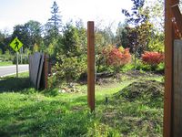
Robyn resisted entering private property here
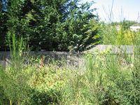
but managed to lean over the fence
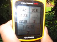
and get within GPS accuracy of the point.


