2009-10-04 49 13
| Sun 4 Oct 2009 in Plzeň, Czech Republic: 49.0306115, 13.0173778 geohashing.info google osm bing/os kml crox |
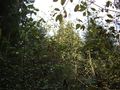
In a shrubbery next to a rather remote bend of the river Regen, a few Kilometers from Teisnach.
dawidi with Tomcat and Hans
After a small detour to 2009-10-04 49 12 on the way to the station, I met up with Tomcat and Hans on platform 9 as a delay of about 15 minutes was announced. By the time the train arrived at Plattling the delay had grown to 20 minutes, and the Waldbahn rail car we had to change to had just left when we came to its platform. So we lost an hour, waiting for the next train. Shortly before 11:00, we arrived at Regen. Of course, there were some geocaches on our way (and some more a bit out of the way), which meant we didn't make much progress towards the hash until 13:00 or so; at least one of them was rather cleverly disguised as a tree stump (with unobtrusive arrow markings on top instructing us to unscrew it), the others were unspectacular, and two of them we didn't find, the first of which had us standing next to a paddock full of curious cows, with the coordinates pointing to a chapel on a hill in the middle of the paddock.
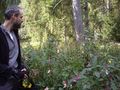
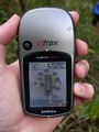
As we approached that rather quiet corner of the woods where the hashpoint was supposed to be, we had a little argument about the discrepancies between the route Tomcat had planned using satellite imagery, the complete lack of tracks on OSM, the various forest tracks on the Garmin topographical map, and the rather lower number of actually existing and/or usable forest tracks... partially caused by the local people having recently carved new tracks (some of which abruptly ended in the middle of the forest). Especially on the last few hundred meters, Garmin shows 3 tracks leading onto the "peninsula", none of which actually exist - instead we found one track in a different position, but even that simply disappeared about 100m short of the hash. So we stomped our way down the slope and through the shoulder-high, "explosive", ripe jewelweed, and found the hash a few meters inland between younger trees where we could barely stand upright.
After taking pictures there, we found there was a small strip of shingle "beach" down by the riverside, and spent a few minutes in this rather nicer spot. It looked not that different from what I had imagined seeing the point on Google Maps after hash o'clock on Friday, but was rather less accessible (which was underlined by the absence of any man-made trash). On the way back to our bicycles, which we had left in the forest, we found bite marks on tree stumps and "slide marks" on the ground - evidence that a beaver lives here.
Tomcat persuaded us to try to find his planned route for the way back - and surely, after pushing our bikes uphill on a different, weathered track for a few minutes, we suddenly found ourselves on a fine, well maintained gravel path, which seemed almost unreal in a location that otherwise had a very "uncivilized" feel. On that track, we returned to civilization, emerging from the forest next to a "no vehicle access" sign and a barrier. From there, the way to Teisnach was easy to find but partially forced us to use a large, busy road without a bicycle lane.
Originally we had intended to visit the confluence point of 49 13 (and the accompanying geocache) as well, but as we were somewhat exhausted (and Hans' bicycle battery was depleted already), we decided to skip that and head straight to the Gotteszell train station to catch the 18:15 train back to Plattling. With that, we were back in Regensburg even before 20:00.

An close encounter of the Moo kind, near Regen.
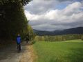
Coasting into a nice landscape...
... more coasting...
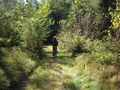
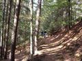
... then on some forest tracks...
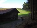
... around the corner of a new farm building...
... and downhill onto the peninsula...
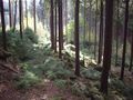
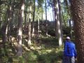
... where the path suddenly ends in baby trees.
Stomping through the "exploding" jewelweed until...
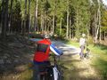
... we reach the coordinates!
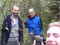
Happy hashers.
Not much to see here, but maybe 30m towards the river...
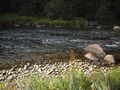
...yay! it's a "beach" :)


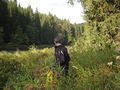
Making our way back through more weed.
Our bikes are up there!
Wow, where did that track come from?
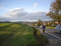
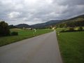
Through Ruhmannsfelden on an annoyingly busy road.
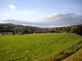
View back into the mountains from near Gotteszell.
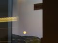
Moonrise, seen from the train.
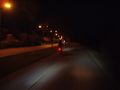
Back in Regensburg, cycling home.


Tomcat, Hans and dawidi earned the Graticule Unlocked Achievement
|
dawidi earned the Multihash Achievement
|