2009-10-18 45 -122
| Sun 18 Oct 2009 in 45,-122: 45.4945374, -122.2894258 geohashing.info google osm bing/os kml crox |
Location
Oxbow Regional Park in Troutdale, Oregon. It is in the woods adjacent to the overnight campsite section of the park.
Participants
Plans
This hashpoint had looked plausible when it came up on Friday, but I was concerned about the distance. But, I programmed the GPS and printed out a couple of pages of Google maps.
Expedition
I had hoped to make it to the Portland hashpoint on Saturday, however, when my couple hours at work helping with a project turned into fourteen hours, that clearly wasn't going to happen. I decided I wanted a break today, so I figured I would head to this hashpoint after running an errand that was in that direction.
Portland, Oregon has, in addition to city, county, and state goverments, a regional goverment that covers (parts of) several local counties. The goal is to coordinate development, existing uses such as agriculture, and infrastructure so that we don't get a lot of sprawl and are able to provide services like water, sewer, green space, and public transportation to the areas were people are living. "Metro" has a couple of parks, and the hashpoint landed in one of them.
I headed to the hashpoint, needing to cross over Portland in the process. This can be a real problem during the day (as it was about a week ago for me getting to the living room hashpoint), but on a Sunday it was pretty easy. As I got closer, the road started to have lots of hairpin turns. The park is nestled up against the Sandy River, which clearly wasn't in a rush to get anywhere fast as it curled back and forth.
When I got to the park, I mentioned I was going to a geohash point, and they said "Oh yes, we have one of those." I explained that this was actually Geohashing, not Geocaching, and that the point randomly moves from day to day. We compared maps and she indicated I could park in the campground, which seemed like the right place to me as well.
I started down the road into the park, and similar to the Hagg Lake hash, the winding of the roads made it pretty hard to use the GPS for much navigation. I knew that I'd go around a loop or two of the river, so I wasn't quite sure if the half mile it was showing at one point was a path that I could actually travel in my non-amphibious car. Eventually, the GPS got down to 0.2 miles, and I decided to start bushwacking.
I had remembered the hashpoint seemed to be about 200 feet from the roadway, so I thought it should be close. However, I started in, and I kept having to divert as I tried to go around downed trees and sections of brush that seemed to have a path around them. I felt like I was looping around but I finally got to 20 feet. Then the direction arrow shifted, but not the distance without my needing to move.
I looked up and realized I'd forgotten about the forest canopy, which was making my GPS reception far below stellar. I circled the stump and shrubs that I was standing in front of, and the readings were pretty erratic. I decided to declare myself there, subject, as always, to GPS error ranges.
Now the challenge was to get out. The stupidity distance had taken over when I plunged into the brush, so I couldn't see the road, or a good landmark from where I ended up. I had also spun around a few too many times to have a good idea of which direction. I worked with the GPS some and managed to backtrack some, but ended up coming out near a different section of road. It took a little walking but I found my way back to my car and headed for home.
It was a very pretty park and it was a nice afternoon adventure.
Achievements
Jim earned the Land geohash achievement
|
Jim earned the Admit One Achievement
|
Photos
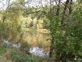
A view of the Sandy River as it passes through the park
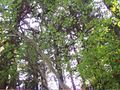
These are the trees degrading the GPS signal for me
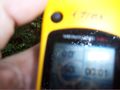
And a poor picture of the GPS showing I made it

My reciept for supporting Metro, our regional goverment


