2009-11-01 45 -123
| Sun 1 Nov 2009 in 45,-123: 45.8439523, -123.0992964 geohashing.info google osm bing/os kml crox |
Contents
[hide]Location
Scaponia Recreation Area, Scapoose, Oregon
Participants
Plans
Jim and APR are probably going to meet in Downtown Hillsboro to head north. Jim may take a couple of furry passengers as well.
Expedition
Jim's travel
I was going to take two furry creatures with me, but the older one was not interested in traveling, so she stayed home and slept.
Aperfectring's Walk
A well worded and very convincing e-mail was received via the portland-geohash mailing list on the morning of hash-day. I suggested that we meet somewhere, primarily so that we didn't spend two car's worth of gas to drive the hour each way towards the hashpoint. I still consider this a meetup, even though we didn't meet very near the hashpoint. It was later determined that I should take the MAX to the end of the line in Hillsboro, the Hatfield Government Center. Since this is only about a mile from my apartment, and it was a deliciously nice day, I decided to hoof it over there to meet with Jim at the agreed upon 2:30 PM.
Our paths cross
After arriving there at about 2:25, I waited for a few minutes, then received an unexpected phone call: Jim would be a few minutes late. This really surprised me, because I had forgotten that I gave Jim my cell number. A few minutes late, Jim pulls up in his truck with a very happy looking four-footed friend named Stella in the back.
The Beginning of the Joint Travels
There are two major directions one can travel to this hashpoint. Through Cornelius Pass, along the Columbia for a bit to Scapoose, then along the Scapoose-Vernonia Highway to the recreation area, or along Sunset Highway to OR-47, then to Vernonia and along the Scapoose-Vernonia Highway to the recreation area. We decided to go along the Columbia on the way, and through Vernonia on the way back, to make a big long loop, but not qualified for the Tron achievement due to necessary crossing of paths.
After driving for just over an hour, we see the sign for the recreation area, and pay the $2 US day-use fee, thus gaining the Admit One Geohash. We drove down to the end of the gravel/mud road, where there were a couple trucks with horse trailers, the owners, and horses in the parking area. The horses were already loaded, as it was getting late in the day.
As we came in, Jim kept expecting the hashpoint to get closer, because that's how it looked on Google Maps. But it didn't. That should have been a clue to us. But it wasn't. (This is sounding like Rocky Horror, isn't it.)
Setting Out on Foot
We then proceeded to analyze what direction we needed to travel into the park to be able to reach the hashpoint. This would turn out to be a constant problem for us, since wooded areas rarely have good GPS signal. There was a creek running along the park "road" on the side we needed to be on, but luckily there were a few handy bridges as well. We decided that the westernmost bridge was the appropriate one, and grumbled that we should have parked the truck much closer to it. We mark the point, so that we can find our way back if lost.
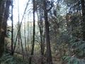
We cross the bridge, and luckily there is a decent, though narrow, trail going in the general direction we need to go. Thinking back, it was likely just a game trail down to the creek, but it served our purposes for a while. It was along this creek that our GPS units decided to switch off which was getting signal and which wasn't. When the trail started to get a bit overgrown, we decided to start the Stupidity distance meter at about 450ft (140m) to the hashpoint.
The Beginning of Stupidity
All reliable data (which wasn't much) indicated that we had to climb this rather steep (>50% grade), wooded, and overgrown hill to get to the hashpoint. I mention we didn't have much reliable data. We, being a couple rational people, were going to relatively clear spots, getting a reading of distance to the hashpoint, and reading them off to each other to try and triangulate the position of the hashpoint. About halfway up, the way up was rather difficult, and we decided that, though we could probably make it up this hill, making it back down may prove too injury-prone for our liking. We decided to abort the direct attack at about 300ft (90m) from the point. Feeling a bit dejected, and rather like Mother Nature's Bitch, we retreated down the hill to about 400ft (120m) from the hashpoint, and saw that there seemed to be a (slightly) gentler approach if we circled around the hill a bit.
On our way around, we encountered many a downed tree completely blocking our path, but the ascent was much more gradual, more along the lines of 20-25% grade. After finally making it to the top of the hill, we were at about 200ft (60m) to the hashpoint, and still triangulating our destination by reading aloud distance and bearing whenever it was available. After crossing one last downed tree, we notice a clearing up ahead. Realizing we are actually somewhat close to the hashpoint, this seems like a blessing. Maybe the hashpoint is in the clearing! If nothing else, we can get a good clear reading of where we are!
The Realization of Stupidity
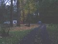
As we approach the clearing, we realize this isn't just any old clearing, it is a road. Not only is it a road, but looking at Google Maps' satellite imagery after getting back, it is a road rather visible, and quite close to the hashpoint.
The Taste of Success
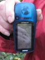
We walk down the road in the general direction of the hashpoint (we are counting this distance in the estimation of stupidity distance to), and find that the hashpoint is rather near the road. We go to a point which appears to be correct, and our GPS units say we are within 30 ft of the point. Given the inability to get signal in this area, we circle the point a little bit, and decide to call it as reached. Success photos are taken, and there is much rejoicing.
The Journey Back
Not fully knowing where this road leads (we were oblivious to the Google Maps imagery at this point), we decided that it had to lead to some road. Since we had driven here on the only decent-sized road in the area, it seemed reasonable to assume that this road went to it. Since we would not be traveling through stupidity-level terrain on the way back, unless this road didn't in fact lead back to the main road, we decided to tentatively call the end of stupidity distance back as being when we got onto the road. This gives us a stupidity distance towards the hashpoint of about 750ft (230m), and about 30ft (10m) from it, thus being a very extreme example of the Stupidity Inequality Hypothesis.
The way back involves some discussion of this extreme ratio for the stupidity distance (about 25:1), and some deja-vu (didn't we just pay an entry fee here?). After returning to where the truck is parked, we cleaned off our shoes, and began on the hour long journey back to Hillsboro. Jim kindly dropped Aperfectring off at his apartment, before continuing on his own way home.
This geohash marks a successful meetup connection between the South Florida community and the Portland community!
Final Tally
- Mother Nature: 1 (There is only one mother nature, so though she thwarted us both, it was with one blow)
- Human Stupidity (in number of stupid human attempts): 4 (One each for the initial failed ascent of the hill, and one each for the circuitous route around the hill)
- SD(from)/SD(to): 750ft/30ft
- Mother Nature is My Bitch: 1 (pending community approval) Or maybe just the MNB
Awards
Jim and APR earned the Mother Nature's Bitch
|
Jim and APR earned the Meet-up achievement
|
Jim and APR earned the Land geohash achievement
|
Jim and APR earned the Admit One Achievement
|
Photos
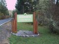
Sign for the park. We saw it 3 times.
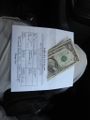
Proof of payment!
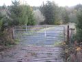
Submitting payment
This was the parking area with horse trailers
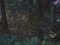
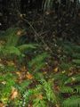
The underbrush we were tromping through
The slope where we gave up. For a while.
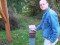
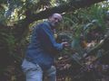
Jiml at the point of assumed failure.
Towards the clearing
At least there is a nice view from up here.
The road less traveled.
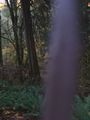
Fuzzy proof

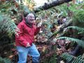
APR at the hashpoint
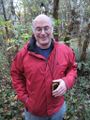
Jiml at the hashpoint.
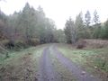
The road more traveled.
At least we would have had to walk in...


