2009-12-01 48 12
| Tue 1 Dec 2009 in Landshut, Germany: 48.9820922, 12.0438290 geohashing.info google osm bing/os kml crox |
On the edge of a field, next to a Danube backwater between Sinzing and Pentling, a few kilometers up the Danube from Regensburg.
dawidi
It had been raining all day. Initially I had had the idea to visit the coordinates before going to work, but it turned out not doing that was a good idea.
I started the expedition at 22:40 (since it just didn't want to stop raining) and wore rubber boots. I only had to cycle 4km along the Danube on a familiar small road. Of course, the one time a car passed me was the only place that had a sizable puddle on the road, and the car gave my jeans a wet leg. At 4°C, I briefly thought about canceling the expedition there, but it didn't feel as cold after a minute or two so I continued. I parked my bike next to the road about 200m from the hashpoint and walked there along the muddy edge of the field.
The coordinates were exactly on the edge, which was good, since I wouldn't have wanted to walk into the field (where things were already sprouting) or closer to the backwater (a slippery slope with thorny bushes). Sometimes, the algorithm just finds the sweet spot ;-)
After taking a few pictures, I started hearing odd sounds from the water (maybe a beaver?) and retreated back to the bike. Only when I arrived at home around 23:40, I discovered just how much "soil samples" I had brought home in my boots' tread...

bleh... flash photo
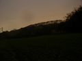
View to the east
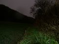
View to the south, along the edge of the field

View to the west, to the backwater
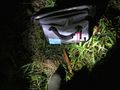
The wet bag marks the #.
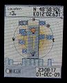
Coordinates reached.


