2009-12-04 45 -122
| Fri 4 Dec 2009 in 45,-122: 45.3838445, -122.9562416 geohashing.info google osm bing/os kml crox |
Contents
[hide]Location
South of Hillsboro, Oregon. Near Hwy 219.
Participants
Plans
Jim is going to go see if he can get there before setting up for robotics.
Jim printed out a Google Maps page, but didn't study the data very much.
Expedition
I thought this would be a pretty easy expedition, forgetting about a extension of the stupidity distance: The first 80% of the travel is pretty easy over roads that you probably know well. The next 10% you might want to pay attention to the map. (You did bring a map, didn't you?) The last 10%: well, "what sort of stupid was I to think I didn't need hipwaders/climbing rope/crampons/etc to get to there".
The first part of the trip was nice, and pretty easy. It has been clear for a couple of days, and the area is very pretty. It was below freezing overnight, but the sun was out, so it was clear and crisp. I had a few turnarounds when I got close and I tried to figure out how far down the Hillsboro-Silverton Highway I had to go to get there, but once I turned the correct corner and headed the "unusual" (for me) direction, I found the side road that leads to the hashpoint.
I found a place to park on the side of the road, near to the hashpoint, which is actually unusual in rural Oregon - the side of the road usually had a large ditch that has room for your vehicle, but it will be on its side and everyone will be pretty unhappy.
I walked up the driveway and walked to a nearby house and sought permission to head to the hashpoint. At first no one answered, and I gave up, but as I was walking up the driveway, the door opened and someone looked out.
I explained what I was doing and sought access. At one point, I pointed in what turned out to be the wrong way and said "It's that way about 200 feet". They said I was welcome to look for the hashpoint, but to be wary of the creek as my boots might not be tall enough. I agreed and said if that looked like the situation, I'd decline and declare it a possible gator-infested zone. Of course, last nights freezing temps might make a gator have second thoughts about the area.
I returned to my car for taller boots and headed into their backyard. I headed up to the rim of what looked like a chasm thought: "It's in that pond". Then I looked at the GPS. It was pointing away from the pond. Score!
But it was still into the chasm. I slowly made my way down, thinking that I need to get a walking stick or something like that for these hikes. I headed down, and the distance ticked down, but it wasn't very stable. Finally, I realized that the trees were thicker than I was thinking and I was getting a poor signal. I wandered around a little and found that I couldn't get closer than about 20 feet without the GPS pointing randomly in a different direction, so I declared the point located. Then I had to find my way back up the slope, but usually going up a slope is easier than going down.
I took some photos and headed back to the car. I changed shoes and headed off to do errands before helping setup for the local FIRST Lego League robotics competition.
Photos
Most didn't come out very good.
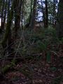
This was the slope to leave hashpoint

Jim earned the Land geohash achievement
|
Jim earned the Ambassador achievement
|