2009-12-19 44 -92

| Sat 19 Dec 2009 in 44,-92: 44.8432908, -92.7701670 geohashing.info google osm bing/os kml crox |
Location
In Afton State Park, Minnesota. Near a group campsite, about 500 feet from the roadway, and probably over the embankment toward the river.
Nathan came within 500 feet, but due to lack of a GPS and unpreparedness, went off in the wrong direction.
Participants
Plans
Nathan
I'd looked up the location Friday night, and it looked potentially reachable, though without a GPS, I'd only be able to approximate the location. It's a 30 minute drive from home, but there's a shop along the way that I wanted to check out.
Saturday morning, I checked to see if my phone and internet had been installed (scheduled to be done by Friday evening) but no dial tone. I called the company, between what they told me and what I learned by talking to my neighbor, I determined that they had mistakenly connected the service to the other unit at my address. Another phone call to the company resulted in a technician visit scheduled between 12 and 4pm. Well, if the phone company lives up the the stereotype, there's no way I'll make it by 4pm.
About five minutes to noon, my cell phone rings, and the tech is about five minutes away. He arrives, moves a few wires, and I have dialtone/DSL sync. Yay, now I can stop stealing the neighbor's wireless! Ten minutes after he arrives, he's gone. Guess I'll make it after all.
Aaron
I grokked this event about 3:20 PM on Saturday while I was at work in Minneapolis. I hopped in the car and gave my Garmin the closest intersection to the site. I had no boots, hat, or gloves.
Expedition
Nathan
I set out, stopped by the shop and discovered that they looked suspiciously out of business, and proceeded on my way. I arrived at the park without incident, and discovered that there was a $5 day use fee. After stopping in and buying my pass, during which I was trying to decide how I'd explain what I was planing on doing, if the lady asked (she didn't) I was once again on my way. It was probably 3:45 when I got to the park.
I found my way to the nearest approach by road quite easily, and discovered that the area was a group campsite--quite vacant due to the snow, but surprisingly, the loop around it had been plowed out. It was then that I realized what I forgot: I'd looked at the map several times, and printed directions to the end of the road, but apparently I neglected to print a page that showed the hashpoint in relation to the road.
I set out in my best guess of the correct direction, and as I left the clearing and entered the trees, I spotted a deer dashing away from me. Unfortunately, I wasn't quick enough with the camera to catch it. The area was fairly easy to traverse, about 4" of snow, and very little underbrush, so I just picked a direction and headed out. I went what felt like the right distance, and up to the point where the grade of the slope became much more steep, and decided that I was as close as I was going to get. I took several photos, including several through the trees of the St. Croix River, which is mostly covered with a thin layer of ice. I nearly forgot to take a picture of myself, but remembered at the last second.
I stuck around for a few more minutes, and headed out--the return trip was entirely uneventful.
Once I got home, I consulted the map, and determined that while I had correctly identified the end of the road, I had set off from the wrong point in the campground loop, and in the wrong compass direction, and so while I was on foot I was moving away from the hash. That means that my closest approach was about 450 feet, and by car.
The wording is unclear, but I'm claiming the Admit One Achievement despite my lack of actually reaching the hash, since I paid for access to the point I reached anyway.
Aaron
I made it to the park at 4:08. I passed the group campground entrance and went directly to the visitors center. I met 3 people walking their dogs, roamed around a bit on the trail. Looked high and low for Nathan, but to no avail. Given my horrible state of unpreparedness, I opted not to try slogging around in the snow. I returned to my car and drove home.
Had I turned right at the group campground entrance I would have most assuredly found Nathan, but it was not meant to be.
All in all, a good time seeing a very nice park (even saw a couple deer crossing the road in front of me).
Achievements
Nathan earned the Blinded by Science Consolation Prize
|
Nathan earned the Admit One Achievement
|
Photos

Me, mugging for the camera while standing in the wrong place.
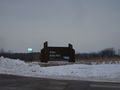
Entrance to the park
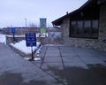
$5 parking fee required
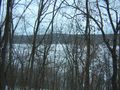
View from the spot I reached. You can see the St. Croix River, and Wisconsin on the other shore.
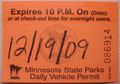
Proof of payment for Admit One Achievement


