2010-01-04 44 -92
| Mon 4 Jan 2010 in St. Paul SE, Minnesota: 44.0479720, -92.4291881 geohashing.info google osm bing/os kml crox |
Location
In the middle of south-bound East Circle Drive next to Century High School in Rochester, MN.
Participants
Expedition
With hopes of Cold Geohash glory, Mark waited until midnight and hoped for the coldest. Pushing his luck by trying to combine as many achievements as possible, Mark plotted his route to be ready to go Tron if the option arose, timed his driving to arrive right at midnight, studied his thermometer logistics, and even wound around extra roads to perfect the timing. Managing this many variables, it couldn't possibly work.
As he drove over, things were looking good. The car thermometer read -24 C and midnight was fast approaching. But wait! Starting up the hill, atop which lay the hashpoint, the temperature began to rise. By the top it was up to -22 C. A detour through a neighborhood to give it time to drop and delay a minute or two, but it was solid at one degree too warm.
Hopping back onto East Circle Drive with 160 meters to the hashpoint, Mark hoped he could accelerate quick enough to salvage the Speed Racer. Camera in shifting hand, GPS wedged in the dash, video rolling, and BBC radio playing, he opened the throttle and gave it all he could. With one eye on the road, and the other on the "distance to waypoint" he flew through the green light.
No! "0.01 miles" was as low as it got. Spinning around at the first chance and passing again on the other side of the road before midnight was up, he tried to secure victory. But, alas, the numbers were higher this time. Tron achievement thwarted, he pulled into a parking lot and parked the car.
Walking over snowbanks while wearing sandals, he ventured into the empty road. After a bit of following the arrow, distance to waypoint finally hit zero. Right in the middle of the lane he had been driving down. The GPS was just too slow to display.
Quickly hopping back into the car at the sound of sirens, he reviewed the data with nearly frozen hands. Video looking good, and sirens turning out to be fire trucks instead of police responding to reports of a crazy man walking in the ditch, he headed home, driving right past the fire trucks which turned out to be headed to the next building over from where he parked.
The next day, with the track log opened in a text editor, Mark set to calculating if he really did pass through the hashpoint. Indeed he had, with one track point 50 feet on side and the next about 150 feet to the other side. 54 feet being the peak accuracy of his GPS, the data was good enough. A little more number crunching, the distance between the two points came out to 0.05337 kilometers, or 0.0331625805 miles. Divided by two seconds and multiplied by sixty seconds and just as many minutes yielded 59.69 miles per hour. Good enough, on a 55 MPH road.
Déjà vu geohash achievement was also satisfied on a factual level, though suffering from repressed narcissism Mark lacked photographic evidence. Searching track logs from the 2009-11-14 44 -92 expedition, in which he and Rhonda drove their cars directly through this hashpoint en route to their golf geohash, and earlier track logs from scouting the same expedition, the closest evidence was record of Mark departing the area immediately beyond this hashpoint at high speed. Further evidence pending, but after 8.5 years in this town he will come up with some sort of explanation showing use of this major roadway.
Photos and really horrible video yet to come....
Achievements
Mark earned the Frozen Geohash Achievement
|
Mark earned the Speed racer achievement
|
Mark earned the Midnight Geohash achievement
|
Mark earned the Déjà Vu Geohash Achievement
|
Photos
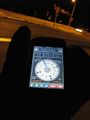
Coordinates Reached
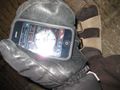
Goofy Footwear for running around in snow drifts
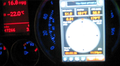
Driving fast in very cold weather
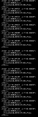
Data to back up claims

More data to back up claims


