2010-01-08 60 10
| Fri 8 Jan 2010 in 60,10: 60.5807581, 10.5583829 geohashing.info google osm bing/os kml crox |
Location
At the end of a small street in Hagar, near Eina, Norway. And then some 50m through the snow.
Participants
Plans

A hand-drawn map, and the coordinates stored into the compass app for the android phone. What could possibly go wrong?
Expedition
Relet set off in the morning, driving from Ringerike in the direction of Eina. He soon realized that, unlike he had remembered, the car does not display the outside temperature in the dashboard. So much for beating the cold record easily, with the outside temperature at roughly -25°C. The cheap thermometer he used the last time has a flat battery requiring disassembly to be exchanged. So he did not even think of bringing it.
However, he did enjoy the snowy landscape. All the beautiful Norwegian lakes were completely frozen and snowed over. The hash would be right next to one of these plains of snow and ice, on the other side of a railway track, down a few roads connecting the scattered houses. He crossed from the snow-cleared main roads to the snow-flattened side roads, and eventually found the railway underpass his map indicated. It was barely a car wide, giving view on an even less cleared road up a hill.
However, the roads actually are the better to drive on, the less cars do it. With that in mind, relet continued the ascent up the hill. The only actual problem is that nobody cares to hollow out parking spaces, when clearing snow. He eventually found a space where the snow plough must have maneuvered and decided to park the car there, and to go the rest of the distance on foot.
The map he had drawn showed an unlabeled track (check), having several branches (check), heading roughly south (check). He trodded on. The air and the snow was so dry, he had to remind himself to drink much. Lest a headache would remind him soonish. His winter clothing held him reliably warm enough, with maybe the only exception of his boots, which were originally meant for hiking in summer. But with the core at sweating temperatures, there should be little risk for the extremities.
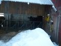
He followed the main road, with all the branches leading soonish to one house or another. Dogs barked (apparently, some people keep a lot of dogs, to pull their sleighs). He passed nicely decorated houses, then a cowshed, and then the cleared path ended.
His GPS/compass thingy still indicated 2.0 km to go - definitely too far to plough through the snow. And for some reason, it always pointed to the right. At this moment, he realized that he probably had just become victim of the famous Gjovik graticule, spoiling every geohashing attempt until now with waist deep snow. Just wanting to get a fell for this, he quickly admitted defeat, took a fail-panorama, and headed back for the car. On the way back, he was consolidated by the sight of a very cool kitteh.
Having reached the car, relet considered if maybe he had just taken one wrong branch on his map. But he decided not to trod back, and drove home. Eventually, eventually, back in the hotel, he realized the two actual reasons for his defeat.
- A typo in the coordinates entered into the GPS. He really had only been about 250m from his goal.
- His snow gloves contained two powerful magnets, allowing them to stick together when they are not used. This is not useful when trying to operate a compass in cold weather.
Moaning and complaining, he decided not to be fooled so easily tomorrow, and reiterated the search for suitable hashes.
Ribbons
This user earned the Blinded by Science Consolation Prize
|
Photos
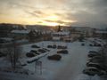
Ho/nefoss at dawn
...and with a different focus. It's -22°C outside.

The library, cinema, shopping center, and a car.
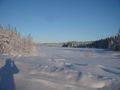
A frozen lake.
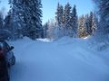
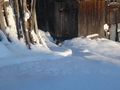
Where the tracks branched, and the car remained.

relet trodding on
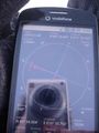
Double technology fail: Wrong target coordinates (upper right) and compass pointing towards left glove (north pole)

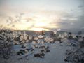
The path ends here - a failorama
Geokine
Geokitteh (it had it's own trampled path)
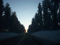
Sunsets are amazing


