2010-03-12 50 11
| Fri 12 Mar 2010 in 50,11: 50.9518244, 11.8367594 geohashing.info google osm bing/os kml crox |
Location
In the middle of Autobahn A9 between exits Eisenberg and Bad Klosterlausnitz. Great opportunity for a speedracer achievement, since there is a 130km/h limit for the south direction, starting right after exit Eisenberg. There's no speed limit, if you're going north. Taking the left lane in any direction, you should practically drive through the geohash.
Participants
Plans
- Manu would just have to miss the exit Eisenberg on her way from Leipzig to Jena/Reinhard.
Expedition
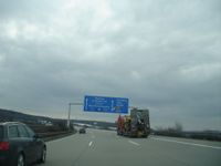
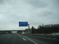
Manu came back from Hannover to Leipzig and immediately continued with her own car to her beloved Reinhard. She did as she was told (see 'Plans') and concentrated on driving at 130 km/h, while she was taking blurry photos. Since she recorded her trip with the GPS device, she did not have to take a sharp photo of the device or her speedometer at the exact position.
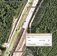
A part of the log file is shown below. The coordinates are shown on the satellite view in picture 4, which also shows the hashpoint right in between. The distance between the adjacent recorded points is 246 m. At a speed of 130 km/h it should take 6.81 seconds to drive that distance. As you can see in the log, it took 7 seconds (plus/minus 1 second) – Speed racer award achieved!
      <trkpt lat="50.952091217041" lon="11.836895942688">
        <ele>284.687622070312</ele>
        <time>2010-03-12T15:28:11Z</time>
      </trkpt>
      <trkpt lat="50.950065612793" lon="11.8354825973511">
        <ele>287.571411132812</ele>
        <time>2010-03-12T15:28:18Z</time>
      </trkpt>
Photos
|
Awards
Manu earned the Speed racer achievement
|
Manu earned the Land geohash achievement
|


