2010-04-06 48 11
| Tue 6 Apr 2010 in 48,11: 48.2117945, 11.1908889 geohashing.info google osm bing/os kml crox |
Location
Approx. 1 km E of Mammendorf, on a field and very close to an intersection that was clearly visible on maps and satellite images.
Participants
Plans
The plans were: Do not work long today, take an early train, check out the spot and be home in time to cook dinner and have it ready at 8 pm.
Narrative
The plan worked out. Some Details:
- After having biked more than 100 km the previous day, I felt like not getting up at 6:15 and instead turning this into a short day at work (i.e. no lunch break and 4h <= t_work <= 6h).
- Despite the fact that my bike was not at the train station but at my company and I therefore had to walk after getting off the train in the morning, I just made it in time to not violate the lower limit for t_work stated above.
- I actually did get some stuff done during the four hours at work. I took one of the local (RB) trains that I usually avoid in favor of the express (RE) trains since I wanted to get off in Mammendorf.
- Everything about finding the coords was smooth and easy. Everything went well because the landmarks were very obvious. Again, I was amazed how good OpenStreetMap (OSM) is compared to Google Maps. The bridge North of the location and the new road across it were accurately displayed on OSM, but only hinted at on Google Maps. Also, the smaller roads between the fields were all there on OSM -- even the very tiny ones. Awesome!
- This geohash is the one where I saw the coolest garbage compactor/shredder ever! Look at the pictures below, and I am sure that all y'all will agree. This thing was incredibly cool looking. I thank the algorithm for constantly taking me to places where I see stuff like that.
- Also, the weather was just beautiful.
- The plan to have dinner ready when Mar would come home was achieved as well.
Photos
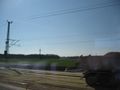
A look outside the train window in the morning. The coords are already visible.
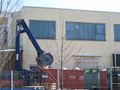
OMG! OMG! OMG! I could not believe my eyes! Never in my life have I seen a shredder as cool as this one! It obviously is used for compacting wooden crates in the container.
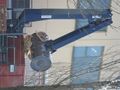
This is soooo cool! I bet only the employees who rank top on the seniority list at this warehouse get to operate this fine piece of machinery. (Don't miss the video on the weblink!)
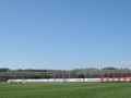
Another view towards the coords. They're right in front of the red car.
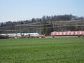
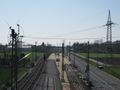
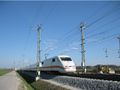
An ICE train overtaking a suburban train (423) at the transformer station in Mammendorf.
Shiny new aluminum wires, shiny trains. I should get money from Deutsche Bahn for uploading pictures like these.
Really. PR department of the mighty, mighty DB, if you pay for geohashing, lemme know via e-mail ;-)

Pilot geohashers (I know you are out there!), could you please let me know why a contrail designer would take detours like this one? Maybe something similar to a holding pattern at cruise altitude?
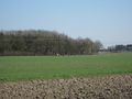
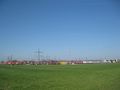
I'm positive that the coords are at least close to what looks like a green triange in this picture...
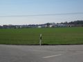
... And they are defintely within the green part of this picture.
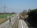
Looking towards München from the bridge N of the coords. The express tracks (l.) are finished, the local tracks (mid) are being rebuilt.
Looking towards Augsburg from the bridge N of the coords. The express tracks (r.) are finished, the local tracks (mid) are being rebuilt. The track on the far left is the suburban train (S-Bahn).
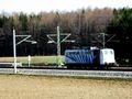
A Zebra owned by Lokomotion. I usually just see them sitting in Berg am Laim. Great to know they're not just stored but actually in active service.
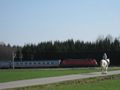
Despite the greatness of the garbage compactor, this is my favorite picture of this geohash. 0.746 kW (1 hp) vs. 6400 kW (8583 hp). I highly question that more kW really means more pretty.
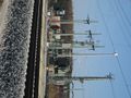
Close view of the XFMR station N of the coords.
A classic one. In service since 1991, or something, and having accumulated (very) approximately 10 000 000 km since then.
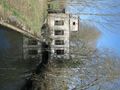
Very pretty building N of Mammendorf. Could have been a smallish power plant many years ago?


