2010-04-09 49 8
| Fri 9 Apr 2010 in 49,8: 49.2350413, 8.3068176 geohashing.info google osm bing/os kml crox |
Location
In the forest south of Westheim, west of Germersheim
Participants
Plans
Somewhere in the forest west of Germersheim, south of Westheim and Lustadt. Koepfel will try a train-bike expedition (RB to Germersheim, arrives 15:08, bike ~6 kilometers from there). Also possible: bus to Westheim or Lustadt Rathaus, but as buses back go through several other villages and take forever, I'll probably take the bike. Germersheim is also reachable for VRN-ticket owners. Koepfel talk 20:15, 8 April 2010 (UTC)
Expedition Report
Koepfel
I started at home at about 14:15 and biked to the Hagsfeld station to catch the local train to Graben-Neudorf. There, I changed into another train to Germersheim. By 15:09, I arrived there. My train was a class 628 dmu, in the next years, the line Germersheim-Graben Neudorf-Bruchsal will be included into the Rhein-Neckar S-Bahn system, so more class 425 emus. The line Germersheim-Wörth will be electrified as well and included into Karlsruhe's light rail/S-Bahn system by the end of the year, so lots of pylons for the catenary were stored near the Germersheim station.
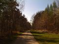
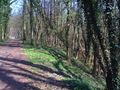
Leaving the station, I eventually turned left into a road named "US Army Depot!". Thinking back to my previous expedition into the forest west of Germersheim, where I was forced to a larger detour after Google Maps wanted me to drive through the army base, I checked several maps for public roads before this time. All maps showed a public path north of the base, Which was in fact there. After cycling past the army base, I entered the forest.
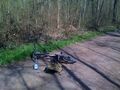
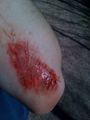
After crossing the road that continues to the village of Westheim. it happened. While checking the remaining distance on my phone and steering with only one hand, I drove over a pothole and fell, reulting in a ~10 centimeter wound on my left elbow. While the bloody wound looked shocking, it didn't actually hurt that bad, so I used most of my drinking water to clean it, rested for a few minutes and continued to the hashpoint.
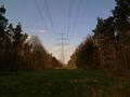
I then came upon a forest aisle, cut down for the power lines. The hashpoint was a few meters north up that aisle and then a few meters east into the forest. I parked my bike and went on to do the GPS dance.
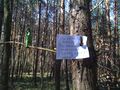
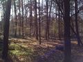
I found the exact spot around 16:00. It was located in a forest, less undergrowth than on the expedition to Zeiskam last year, which was just a few kilometers away. I wrote a marker and took photos and a video.
Trains at Germersheim left at *:49, so aiming for the 16:49 one, I left the hashpoint a few minutes later. The ride back went without problems, I loaded the bike into tha train that was already waiting and cleaned the wound with water from the sink in the train toilet.
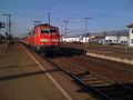
In Graben-Neudorf, I had to change trains again. To my surprise, it wasn't another 425 emu, but a class 111 engine, pulling red Silberling cars. These cars have become rather rare on Germany's tracks. They have very comfortable seats (compared to the 425), but steep stairs at the door, making it impossible for people in wheelchairs to enter, even lifting your bike in there isn't easy. Also, they lack bike compartments, which is why I had to park mine in front of the door. I exited in Hagsfeld, biked home, arriving by 17:40.
Koepfel earned the It's just a Flesh Wound achievement
|
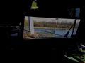
Crossing the Rhine river
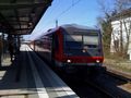
arriving in Germersheim
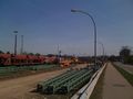
new pylons for the Germersheim-Wörth line
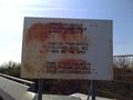
No Parking, in German, English and... Turkish
Ouch
Reached
Hashpoint
Silberling train in Graben-Neudorf


