2010-05-02 49 -123
| Sun 2 May 2010 in 49,-123: 49.3530534, -123.0108065 geohashing.info google osm bing/os kml crox |
Contents
Location
Near Rice Lake in North Vancouver, beside Rice Lake Road.
Plan
Meet at the Lynn Canyon Ecology Centre around 18:00.
- Woot! I assume the general public is allowed to drive up there use their parking lot? Yangman 17:32, 30 April 2010 (UTC)
- Yes, the ecology centre has a public parking lot -- Rhonda 17:34, 30 April 2010 (UTC)
- I'm going to be driving back from Kamloops that day, so I will probably be there late afternoon or early evening -- Rhonda 17:33, 30 April 2010 (UTC)
- Afternoon/evening would work better for me as well since I'm returning from Whistler Saturday evening. -- Yangman 18:00, 30 April 2010 (UTC)
- I'm in. Say what time, Rhonda. -Robyn 20:38, 30 April 2010 (UTC)
- Woohoo! Robyn's back! I'm not sure exactly what time I'll be able to make it. I'm hoping to leave Kamloops shortly after lunch, so might be getting home about 5PM, if I leave when planned. Plan for 6PM? Thoughts? -- Rhonda 20:55, 30 April 2010 (UTC)
- We failed to leave Kamloops after lunch, chances are we won't be getting into town until well past 8:30 or 9pm. We might take a stab at getting there past dark, play it by ear.
Participants
- Robyn - made it
- Rhonda - didn't make it
- thepiguy - made it
- yangman - joined the expedition late
- Wade - made it
Expedition
Preface
thepiguy's favorite part of going on an expedition with Robyn, is reading her report after. Almost more so than actually going on the expedition!
But since Robyn is currently busy flying a very small plane across a very large country, thepiguy and Wade will provide a brief summary:
There was rain. We got wet. We were successful, and ate nibs.
You'd think thepiguy didn't go on the expeditions if he has to wait for Robyn to write them up before he knows how much fun he had. I'm back from my plane trip, so here goes.
The Gathering
It was a spring day in Vancouver, which means it wasn't as cold as it would have been in the winter, and it was raining. And the Vancouver crowd was going geohashing. Wade and Robyn swung by the King Edward Skytrain station to pick up thepiguy. Sitting in the left turn pocket about to turn onto the street where the station was, Robyn handed Wade a dinosaur and instructed, "Wave this at piguy." Wade asked which of the four people on the sidewalk was pi.
"The one dressed all in black."
"That narrows it to three out of the four."
"The one without the umbrella."
That may or may not have singled out thepiguy, but it was spectacularly irrelevant. Firstly, thepiguy had seen Robyn's car even before she had missed the previous green light, and secondly there is really no way to wave a rubber dinosaur at a specific person out of four standing together twenty metres away. The light changed, Robyn turned left while someone attempted to pass her on the right, but still managed to pull over and pick up thepiguy.
Together we got onto the trans-Canada highway and crossed to the North Shore. "Mountain Highway exit, right?" asked Robyn, who hadn't looked super-closely at the directions, and who was approaching a cluster of three exits. Wade and the talking car GPS simultaneously told her to continue on to a later exit. Robyn didn't realize that Wade was simply reading the GPS screen and thought that it was two against one for the later exit. Geohashing is a somewhat democratic activity. Robyn gave the Mountain Highway exit an affectionate glance and continued on, over a couple of exciting bridges to an exciting exit she had never taken before. It was still raining.
After a couple of tries at getting on the right road from that exit, we got on the road that the GPS considered correct, but then we started to question the knowledge of the GPS. It turns out that Wade had entered the geohash coordinates, and the GPS was leading us to the nearest published road to the geohash, not to the nearest road to a trail that will actually lead to the geohash, and without consideration of the fact that the shortest way to get from the nearest published road to the geohash might be to go back down to the trans-Canada highway, take another exit and come back up on the correct side of an impassable ravine. We turned around in a parking lot and went back down to the highway, where we took another exit that was not the Mountain Highway exit, but which gave us the opportunity to cross over Mountain Highway such that Robyn could point out that the exit she first wanted would have taken us here. And for some reason they keep letting Robyn write the expedition reports, giving her another opportunity to do the same thing, while omitting details of the way she had trouble finding her way out of the parking lot.
The GPS from there directed us unerringly to the agreed-upon starting point, the Lynn Valley Ecology Centre. There was another road closer to the geohash, but it was named Private Road on Google Maps, so we were guessing it might not be accessible. And this way we would have an interesting hike. Sure, it's raining, but it rains in Vancouver; we're used to it. The official meeting time was six o' clock and we had rumours that Rhonda & Xore would be attending, coupled with later rumours that they were delayed. Yangman had also given intentions to come, but by bicycle, and we knew he was hardcore, but this was pretty miserable weather, especially for going home. We waited only until the dot of six and then set off.
The Trail
The parking lot was posted as closing at eight, which means that they close and lock the gates at eight, and probably call Search and Rescue to go and find the owners of any cars they lock in. We were fairly confident we could go what was a straight line distance of less than two kilometres and back in less than two hours, even if it did require a winding trail, especially as there was such a low chance of forest fires. We clutched our hashcots and our hats against the wind and set out. (Yes, it was still raining). The first task before us was to cross a sheer-sided chasm over a hundred metres wide and seventy metres deep, with a rain-swollen river racing through it. To other graticules this may have posed an impassable barrier, but the Vancouverites simply clutched our hashcots a little more tightly and leapt over the edge. Onto the suspension bridge. If only all natural obstacles to geohashing were so conveniently equipped.
No one and nothing fell off the bridge on the way over. (I'll tell you later what happened on the way back). The bridge brought us onto a trail through the woods. As we followed it we met another group of people who asked us if T-Rex was something we had brought with us, or did we find him in the forest? We assured them that his kind was native to the area, and that we merely brought him to ward off other dangerous creatures.
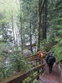
The muddy trail ended at a perfectly accessible road and parking lot. We could have parked here and saved ten minutes of walking, but we liked the walk, so no harm. On the other side of the parking lot was a further, well-groomed trail. It has a high fence on one side signed 'no trespassing' and gates on each side where a heavy duty road crosses the trail. This is the "Private Road" that Google Maps shows our geohash beside. Beside, not on is the key. We continued past the gates into the forested trail network until we reached the point where our GPS receivers indicated that the bearing to the geohash was ninety degrees to our direction of travel. The trails ahead went down a steep hill, so we turned and headed into the woods, with a stupidity distance of just over 300 metres.
The Bushwhacking
The fence preventing us from going onto the road ended about six metres past the road, and seeing as that's where we wanted to be, we and the restrictions were in agreement. Our progress through the bush was relatively easy for off-trail travel. The undergrowth was not thick and there were some sort-of trails, plus the dense forest protected us from the worst of the rain. (Yes, it was still raining). As Robyn made her way across a log bridging a pool of water she asked Wade, "Remember the time we walked across the beaver dam?"
"Yes," said Wade. "I remembered it just before we left, which is why I changed my shoes and pants even though this geohash is supposedly 'right beside the road'."
Piguy's GPS soon declared us within 12 km (plus or minus 27 km) of the geohash, and Wade's GPS continued to recommend we return the the highway and take another exit, in order to reach the geohash. We decided to follow Robyn's GPS, which said the geohash was within fifty metres straight ahead. We reached a bit of a clearing, where the sparse vegetation eased both the forward movement of the geohashers and the downward movement of the rain. Yep: still raining.
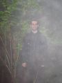
After a bit of circling, Robyn found the point that her GPS considered zero metres from the geohash. She got out her camera, wiped the rainwater off her face, the GPS, the camera, the GPS again, the camera again, and quickly pressed the camera shutter button. Hey why is it a shutter and not an opener? And what's that beeping noise? No answer to the first question, but the LCD screen indicates that the beeping means 'no memory card'. It's the 21st century equivalent of not having the film threaded properly on the sprockets or leaving the lens cap on. Meanwhile thepiguy's GPS receiver had found about two and a half satellites, so pi is balancing it on his head in order to get a better signal. He loaned Robyn his SD card for a few shots so that she could record the moment.
Once thepiguy had proved to his GPS receiver that we had arrived, and we had all eaten a few red-flavoured Nibs, there wasn't much else to do at the geohash. We could, after all, get drenched pretty much anywhere today, no need to hang around here and do it. We moved on.
Thirty-Something Pool
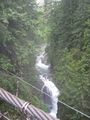
As with almost all geohashes, it was easier going on the way back. We almost hadn't had enough suffering yet. After we passed the parking lot where we weren't parked, we reached a fork in the trail. We knew which way we had come, but we noticed that both ways were signed as leading to the suspension bridge. And the trail we hadn't taken advertised a thirty metre pool. Or maybe a three metre pool or a thirty foot pool. We forget exactly which, but it sounded good at the time. We went down that trail.
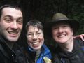
And so did someone else, yangman, who had arrived at the ecology centre at about 18:01 and finally chased us down. We assured him he was now part of a successful geohashing expedition, and together we proceeded down the trail and down a staircase to the brink of the thirty-something pool. Signs (and common sense) advised us not to go swimming in it, so we photographed ourselves in front of it. No one fell in, despite a fair amount of jockeying in order to try and get us all in the picture without putting the camera somewhere where it would get wet. Yes: still raining.
We followed the trail upriver and eventually to more stairs leading back to the suspension bridge. No one and nothing fell off the bridge on the way back, either. I just had to make you wonder. It is a suspension bridge, after all. We returned to our cars. (Yangman had not come by bicycle, after all). Robyn declared that she was not eligible for the Drowned Rat ribbon, as her underwear was still dry.
The Dripping
We'd had such a good time at our geohash that we decided to extend our association over dinner, at a pub that Yangman recommended. As well as the expected food and beer, they unexpectedly provided heaters, blankets, an opportunity to win a mountain bike, and chicken. The chicken was unexpected because it showed up in a dish described on the menu without chicken.
Those who have never geohashed with people from the Vancouver graticule will never know the extent of the fun they are missing, so there is no point in my attempting to further document it. You'll just have to come and join us some day.
It was still raining when we left.
Photos
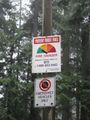
Don't worry! The fire hazard is low!
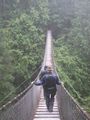
Crossing Lynn Canyon!
That bridge isn't just for show.
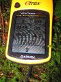
Robyn easily zeroes in on the hash.
While thepiguy tries to get a signal.
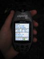
thepiguy finally finds some satellites.
Drip drip hooray!
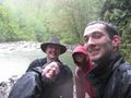
A short time later, and there is one more geohasher!
Sadly we had to walk back up the same height later.
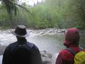
Gazing in amazement at the 30-something pool!


