2010-05-21 40 -111
| Fri 21 May 2010 in 40,-111: 40.2624552, -111.4351431 geohashing.info google osm bing/os kml crox |
Contents
[hide]Location
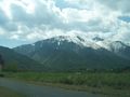
The location for today in Salt Lake City was located on the top of a mountain up Hobble Creek canyon. It seemed easy enough to access, but as with almost all hash points, a couple inches on my computer screen relates to a lot of steps on uncertain ground. But I was determined to reach this hash point, and in doing so believe that I may have reached a point requiring one of the most physically demanding treks yet recorded. I was either stupid enough or persistent enough to compete it, and am happy I did.
Participants
Expedition
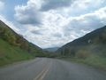
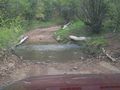
The point was relatively close to the road, only a mile or two distant, and I drove the 70 or so miles down to Springville and up the canyon in little under an hour. The road did get a little bumpy near the end, and at one point I nearly flooded my engine trying to push my little 1989 Camry over Hobble Creek, but I made it relatively unscathed. I think I am starting to murder my suspension. However, I did not get lost, so I consider my driving a success on that point.
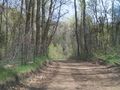
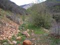
When I came as near as I could to the hashpoint, I parked my car on the side of the road and started looking for a place to head off-road. After a little trekking back and forth, I found an easy-access route to a small brook which I could follow most of the way to the point. When I got to the brook I found by consulting my handy-dandy GPS (that's a Blues Clues reference to those of you who still remember childhood) that there was an old logging road a short bit up the nearest hill. So I abandoned the stream and scrambled up the mountainside a couple hundred feet to where the old road was. I found it easily, and although it was old and grass-covered, it was still passable. I could easily navigate around the occasional fallen tree or tumbled rock when I came across each.
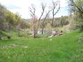
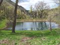
This road went on for a mile or so, joining up with the stream I had left so prematurely. If I had stuck with my original plan instead of taking that detour I would have saved some time. But I also would have probably gotten my feet wet. It was in that respect an even trade. I then followed this logging road for a mile or so more, coming across a beautiful reservoir in the process. It seemed like it was not used as much or even at all any more, but as it was located in a small clearing covered in bright grass the overall effect of the place was breathtaking.
I followed the road and stream as long as I could, not wanting to leave the easy road for the more strenuous brambles and tangles. Luckily I was able to get to the base of the mountain that I had to climb before leaving the road, and all I had to do was go straight up. And I found out later how true that really was.
From the ground, the slope didn't look that steep, perhaps a 50% grade or similar. And as I only had to travel another couple thousand feet I thought it would be pretty simple. However, When I got back I ran my route through Google and found that I had actually ascended a 75% grade rising 36 degrees from the perpendicular. No wonder my legs felt like slag halfway up. There were points climbing that mountain where I wanted to give up and turn back, never mind that I was only a couple hundred feet shy of my goal. Yet I pushed on, and after forty minutes of frenzied climbing, in which I gained 600 feet in altitude and walked a circuitous route which must have taken me at least 4000 feet, I reached the summit.
And it was worth every step.
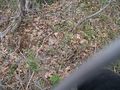
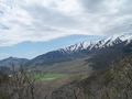
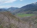
The view from the top was spectacular. I could look back over the verdant valley I had driven up and it was so overwhelming I had to sit down for a moment. Before taking any pictures, however, I navigated my way to the hashpoint, which was another twenty feet down the other side. I took my dutiful picture of the point, but couldn't bring myself to mark the point in such an unspoiled place. Jogging back to the summit, I took out my camera to take some magnificent photos but before I could my camera informed me that it was feeling a little depressed lately--feeling a bit low--, and that even though I had just completed one of the most strenuous treks of my career, it would much rather take a nap and not do any work for the time being. At that point, I almost did something very stupid and was on the verge of committing homicide--or cameracide, or however its classified--when I remembered that I had my GPS, and both the GPS and my camera ran of the same type of battery. I quickly switched them out, and although my camera was a little tired, it dutifully took some spectacular photos.
This done, I packed everything up and quickly made my way down the mountain. It took twenty minutes to descend--half the time it took when I was going the other way. I took my time going back, this time deciding to follow the stream. I did get my feet wet, but I made better time, and I reached the road in no more than twenty minutes. The drive back was uneventful, and I rewarded myself with a ice cold slushy coming back. I really should have thought to bring water.
Hobble Creek
The Point


Awards
Mabeuf earned the 2010 Geohashing Day achievement
|