2010-05-21 52 13
| Fri 21 May 2010 in 52,13: 52.0229115, 13.4999128 geohashing.info google osm bing/os kml crox |
Location
At the edge of a field near Baruth (Mark) in the far south of the graticule in Brandenburg. It's Geohashing Day!
Participants
Plans
- It's a 1 hour train ride from Berlin to either Baruth(Mark) or Klasdorf Glashütte, either way there's then a 3-4km walk through the forest.
- Trains from Hbf (from Bernau and Gesundbrunnen, via Potsdamer Platz and Sudkreuz) run at 09:26, 11:26, 13:26, 14:26, 15:26, 16:26, ...
- Anyone else interested? --davidc 13:53, 20 May 2010 (UTC)
Expedition
I set out from Berlin Hauptbahnhof on the 13:26 train to Baruth on a lovely sunny Geohashing Day. Baruth's mostly quite a pretty village, though unfortunately built primarily along two main roads. I took a shortcut from the station down a tree-lined track to Baruth Park, where I searched for geocache GC1YA2D. I quickly gave up though as the land was excessively boggy and the air filled with insects.
I headed over to another geocache, GC27F0Q nestled in a mighty bifurcated oak tree. This was easily found and I picked up a travel bug to move along.
My plan had been to plunge heedlessly through the forest toward the hashpoint from there, but I decided against this as I had forgotten how quickly you get covered in creepy crawlies walking through a forest in early summer. So I headed down the main road toward what, on my satellite map, looked like a long track heading toward the hashpoint.
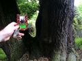
Of course, I was zoomed out on the satellite map, and when I got there, the track turned out to be a massive tract of land deforested for the pipelines below. The sandy soil was soft and freshly planted, and I made good albeit boring progress toward the hashpoint. About a third of the way along, I got off the field and onto a dirt track that had joined parallel. To my delight, I immediately saw a geodesic survey marker affixed to a tree (pictured).
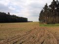
Other than the occasional fawn or rabbit, the rest of the way along the forest edge was fairly bland until the pipeline tract opened out into a wider field and an electric fence interposed itself between me and the hashpoint beyond the far treeline. Fortunately the fence ended abruptly after a hundred metres, though it brought up questions about what it was actually designed to achieve.
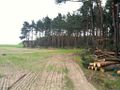
The hashpoint was then easily accessible down the edge of the field, though there was a disparity between where my GPS thought it was, and where the satellite image thought it was. I visited both locations to be safe. Chopped trees in the area indicate that there has been further deforestation recently, so likely the GPS was more accurate.
Having no cake to hand, I quickly doodled one for the photo, took the obligatory photos, planted my hash card, and sat a while on the fallen trees while a tractor ponderously made its way across the horizon.
Going back, I took a more direct route, straight north, along a horse trail back to Baruth. I passed a forest grave, overtook the tractor, and met a mare and its foal being taken for a walk before descending into the basin of the village. By the village green, found a few curious cellars dotted around public land (not attached to any house) that I couldn't explain (pictured).
With no village pub that I could find, I waited at the station for the next train home.
Happy Geohashing Day!


Mystery boxes
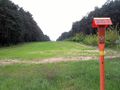
Every time I hash in rural Brandenburg, I find these strange boxes dotted around the fields, usually at the edge of the forest. I originally assumed they were for birdwatching but something about how they are positioned doesn't add up. Sometimes they are in the middle of fields where farmers clearly wouldn't want people trampling crops.
And on this trip, I found a new variant, the "lifeguard chair" that has no enclosure at all, defeating the object of concealing yourself.
Any thoughts?
Photos
I forgot to bring my camera, so excuse the poor quality and complete lack of horizontal alignment in these photos:
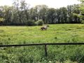
Horsies by Baruth station.
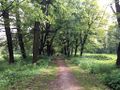
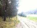
Tree-lined avenue from station to the Baruth park.
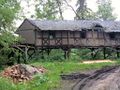
A very cool but dilapidated building on stilts next to the rather marshy park.
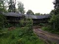
Not long for this world.
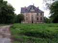
Baruth park castle.
A travel bug and a gigantic oak holding geocache GC27F0Q.
Walking down the road toward Klasdorf.
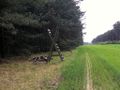
Turn-off into what turned out to be a tract of land for a pipeline.
Pipeline pumping or monitoring station?
Mystery Box mark 2 - no box, just a lifeguard's chair!
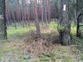
Geodesic survey marker on a tree.
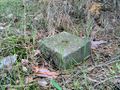
Geodesic survey stone.
Marker and stone together.
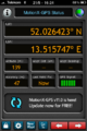
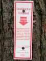
GPS coords of the marker.
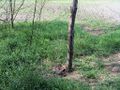
Where in Berlin they number every single tree, out here in Brandenburg they only number each section of forest :-)
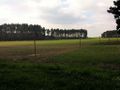
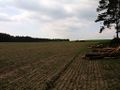
The pipeline tract opens up into a larger field, the hashpoint is beyond the far tree line, but... an electric fence!
Fortunately the fence ends abruptly and shows it was there for no reason at all.
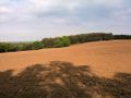
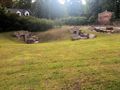
Looking down the hashfield. The hashpoint is beyond the mystery box.
And turning the corner to see the hashpoint in the dead centre of this photo.
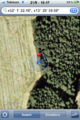
iPhone map proof.
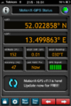
iPhone GPS proof.

That's a cake. With two candles. Happy birthday, geohashing!
A tractor crosses the top of the hash field.
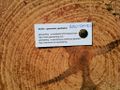
No poster, left a card. The tree sap glistens in the beating sun.
After a flat journey, heading downward back into civilisation.
Baruth has a few of these strange underground cellars dotted around in public places - not connected to any private property.
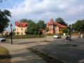
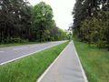
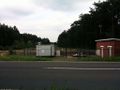
Roundabout joining the two major roads running through Baruth.


Achievements
davidc earned the 2010 Geohashing Day achievement
|