Location
On the slopes of Rauhaugdane, Norways 121st-highest mountain top.
Participants
Plans
Train from Hønefoss to Finse on Saturday: 8:13 - arrives 11:03.
Trains from Finse to Hønefoss on Sunday: 18:18, or 19:00.
Expedition
Another weekend with good weather and faraway hashes, and I was in the mood for more camping. The hashes in my graticule didn't look too promising, so I looked along the railway lines (faster connections than the buses, and more frequent too) for anything interesting. Bingo, there was that hash in the highlands of Hardangervidda (the hard plain widelands) in the vicinity of a hiking path, and within a days hike from Europe's highest train station, Finse. Now, this being Norway, I did not have too much interest in being stuck in the snow again, so I wasn't sure if that would be it. The weather statistics for Rauhaugdane on the other hand showed temperatures up to 15C for the last months, and when I discovered the webcam in Finse train station (which displayed rain), I was all set.
See me live on the Finse train station web cam!. At least when I am arriving waiting for a train. :P
I actually have a picture of me, in the form of a blurry red dot, waiting for my train back. I should upload that some time.
I packed my backpack on the previous evening (having your packs packed is always a good motivation to actually go somewhere) and left in the morning for the 8:13 train. Now, trains in Norway are awesome for several reasons. One: You can buy a ticket online, or on the phone. When boarding the train, you take your seat. The conductor will then come by and hand you your receipt. That's it.
I arrived in Finse after a little more than three hours, where I did some final preparations (such as putting the rain cover over my backpack), and was
| Finse train station, webcam on the left edge |
| Finse from a little further |
| We're following marked trails today. |
| Along an old bit of Bergensbanen rails |
|
The trail, which is marked right from the Finse train station until a mountain hut a good bit southwest of where I was headed, first followed the old railway tracks of the Oslo-Bergen railway (the Bergensbanen). That bit of rails was disused when they had finished to carve yet one more tunnel through the rock. The weather was a bit rainy, but I considered this as a good thing, as the weather report predicted first rain, then sunshine, then a clear night with temperatures of -5C in the mountains. The longer the rain would last, the milder the night could be.
| A patchwork of snow ahead! |
| These can become quite artsy |
|
After disgressing from the railway tracks, it was going up into the mountains. I was soon greeted by the first patches of snow. Their surface in this warm weather did not hold very well, and given the well-known un-quality of my hiking boots, I spent a considerable amount of time to circumvent them.
Next up were three rivers. The first two were relatively wide, and strewn with a few stones that were not more than knee deep under the water. Off with the shoes, up with the pants, and through the refreshing stream. Telescopic hiking poles are a great invention. I also saw, what I had read in the description of the hiking trail, the summer bridges. These are comfortable suspended bridges, rolled out in summer. Which apparently is not now. As with the rest of Europe, Norway had a very long winter, and so they probably just didn't get around to realize the otherwise summery temperatures.
The third river to cross was a little wilder. There too, was a suspended summer bridge - which fortunately in its still unsuspended state had two steel cables crossing the chasm. After crossind the idea of balancing across out of my mind, I merely attached my backpack to the cable, and pulled me across, dragging the backpack after me with my feet.
| Rivers to cross - off with the boots |
| You can see the "summer bridge" to the left. |
| There is only one obvious choice. |
|
From there on, it was several hours of hiking through a landscape of granite and slate, melting snow and mountain lakes. The weather became a bit better, and the temperatures seem to have been a bit cooler too, so that the patches of snow carried better - most of the time. I still tried to circumvent them, taking a route a little above, but always in sight of the stone pillars that marked my way.
The scary bits were when the path crossed a river or lake where the snow hadn't completely molten yet. I often preferred to take a detour instead of guessing where the stones were that would safely carry me across, or whether the snow and ice cover would hold my weight. And too many patches of snow would eventually result in wet shoes. I also passed the glacier of Hardangerjøkulen. Some tiny mountain flowers had already come out into the sun, and surprisingly enough there was a population of insects (larger crane flies mostly) hovering over bits of rock and moss, some of them obviously having frozen in a cold night.
| Resting in the (wind) shade |
| Flowers are found even here |
| What you don't want to see on ice you have to cross |
| They have a weird sense of humour |
|
I eventually disgressed from the path I still could see to my left in a more direct line towards my hash. I would try to pass the four lakes I could see ahead of me on their northern side, instead of the southern side where the path lay. The latter would have meant to make a significant detour, and cross a river in a rather steep valley, before returning towards the hash. What I did not have taken into account, was that there would be a steep canyon here too. The main mistake, I believe, was to believe that the three tiny lakes I could see on the map would naturally empty out into the large basin - and not the other way around. As it turned out, the large basin, that collected all the water from the glacier, emptied out into the first of the three lakes, then into the next, the next, and then steeply valleywards. Resulting in a rather impressive canyon with me on the one side, and the hash about 500m on the other.
| One option to cross that final river... |
| Here's the fourth option. |
|
From a good vantage point, I could see three places where the water narrowed, possibly allowing me a passage. Each of them was naturally marked by wild water beyond anything one could wade through, and none of them had anything like passing stones. I inspected the southernmost, discovering that I could possibly jump from a cliff into the snow on the other side, some five meters below. Besides the obvious madness of the plan, it would not provide me with a safe way back. Then I saw that, a little further down the canyon, the snow still stretched from one side to the other. With barely a roaring mountain river below the thin layers of ice.
I, once again, did the obvious.
| It looks so harmless on the pictures. |
|
I set up camp and called it a day. I guess I considered for a moment if I wouldn't want to swim across one of the lakes, now that I could leave my pack in a safe distance. I guess I would have, hadn't the temperatures reached the point where warming up in the sun was no option anymore. I also mused about the sense of humour of Miss Fate and her Mother Nature that made me think that I was too lazy to carry the extra 2-3kg for a boat, given that the terrain was all landsy and mountainsy up here. It would have been rather easy crossing one of the lakes then.
| I upgraded on the lid, as you can see. |
| Shoes that begin to behave their age. |
|
- Good mornings! Didn't make it.. there was one river too many. Now returning. -- relet @60,5656,7,2716 06:08, 27 Juni 2010 (MESZ)
The return went significantly quicker than the other direction - mostly because I did not care about my rather wet shoes anymore, and just crossed any patch of snow that lay in my way. Starting at 6am and reaching Finse by 11:15 means it took me about five hours to get back, where I took eight hours evading patches of snow, rivers, considering my options and looking at the map a lot.
| More of the things you don't want to see. |
| Dividing the waters: Easier than you'd think. |
| It just keeps going on like that. |
|
I also came across this other roaring river, which passed right under a patch of snow I had to cross - briefly making me wonder whether I shouldn't have tried to reach the geohash on that way.
| Yes, and now cross this river. |
|
I reached Finse in time for the 1pm train, partly because for some strange reason, I did not feel hungry any time during this day and did not have to stop much. I hadn't even eaten much on the previous evening, for the same reason. The glacier water must be a very nourishing one.
| Not going to miss the train this time. |
| Just for the record - I am the red dot sitting on the rear bench. |
|
http://www.youtube.com/watch?v=LLhLLHXzkQo
Tracklog
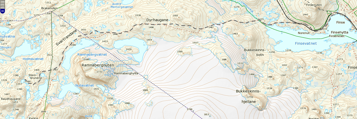
Approximately the way I have taken - minus the detours. The line tool says it was about 16km.
Achievements


