2010-07-03 46 -121
| Sat 3 Jul 2010 in 46,-121: 46.7625283, -121.0616666 geohashing.info google osm bing/os kml crox |
Location
In the Wenatchee National Forest west of Naches, WA in a virgin graticule
Participants
- OtherJack (I had no idea that the Vancouver folks were actually coming to my home graticule on this day... please post on our graticule page to let us know! See here.)
Plans
OK, again DeLorme's (and the Green Trails map) say that it's near good roads... Green Trails is more optimistic. It's 200 vertical feet down a steep (but doable) slope from this maybe-road. But, most importantly, this time it's on National Forest land! So the paved roads leading in will almost surely be open to the public. Unlike last time.
Expedition
Back over Snoqualmie Pass and then over the sagebrush hills on 82, back to Yakima, and then west through Naches to Nile, WA and the detour around the landslide. I love it when random little towns are named after distant locales that they do not at all resemble. The turnoff onto the Forest Service road... it's paved... excellent. And so is the next turnoff, and the next! Just like the more optimistic map said. I should have trusted it. Up and up through beautiful dry conifer forest (eastern slopes of the Cascades) to the maybe-road leading to the geohash. Which is... gravel. Quite drivable (even in a small Hyundai sedan.) Again optimism prevails over DeLorme's which marked it as "unimproved."
Around the horseshoe-shaped valley rim, with huge views of this graticule's namesake on the right. Finally I pull into what must be that little flat saddle space that Google indicated on the ridgetop above the plunge down to the geohash.
I put my pack on, and make my way to the edge. I start trying to clamber down, but it's too awkward with the weight. OK, back to the car. What can I ditch? Jeans - I'm already wearing long pants and the undergrowth doesn't look bad. And I can eat some of my food and drink some of my water. Ditch the sunscreen too since I already put it on. OK. Much better now. Slowly make my way down the steep valley wall. The underbrush is indeed delightfully sparse... lots of grass beneath the light forest canopy, and just a few coniferous shrubs blocking my way. But it's steep, and there's lots of rotting logs that can easily give way, and I have to go several hundred feet along-slope in addition to straight down, as it turns out. It's slow going. But after something like half an hour, I'm there! I'm rather amazed. Graticule deflowered. The climb up to the car is easy and straightforward.
Photos
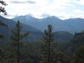
On the drive there.
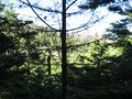
View from the hashpoint. Steep.
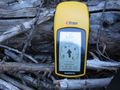
Proof!
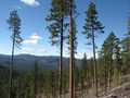
The Cascades from the road. Not sure which peaks.


OtherJack earned the Graticule Unlocked Achievement
|