2010-07-18 40 -89
| Sun 18 Jul 2010 in 40,-89: 40.5965541, -89.4474678 geohashing.info google osm bing/os kml crox |
Location
Southwood Park in Morton, Illinois
Participants
- Dvdllr & Rachel
Plans
Above-average preparation (as far as my expeditions go) went into this geohash. When I found on Friday that the hashpoint was going to be in Morton's Southwood Park, I envisioned walking there for a Sunday afternoon picnic with my wife. We planned accordingly, so we got some food to take along, and picked up a tablecloth to sit on. As for something to do at the park, we also packed Bocce balls to play. All of this, along with the regular stuff (GPS, camera, etc.), got packed into a backpack, and we were ready to go.
We also had to make a contingency plan in case it was raining - all weekend, the forecast for the area claimed thunderstorms for Sunday afternoon. I re-checked it fairly frequently, as if it would change the prediction, but nothing was changing, at least not for the better. Then Sunday itself came around: that morning, the forecast was unchanged. By 1:00pm, the forecast had gone 180° to be nothin' but sunshine the rest of the day.
Expedition
I was shoeless as we left our house. I had figured this would be an excellent opportunity to snag a Hobbit achievement, with the requirements easily accounted for: we were walking there anyway, so I could just do it barefoot; we'd already planned for a meal, so it wouldn't be difficult to split it into two; finally, I am never without a ring anyway (my wedding band). Simple, right? Off we went around 3:30pm. It would take around half an hour to walk there, so we budgeted to get there at four, stay an hour or so, and be back at 5:30.
If you reference the map of our travels, you see the route we took to get there took us through Idlewood Park. It was in this park that we made a pit stop for me to put my sandals on (which Rachel had wisely advised me to pack along). The sidewalks were very hot in the summer sun, and when there were no sidewalks (which was more often than not), I walked on the street, which was both hot and physically irritating. I found that I was quickly growing significant blisters on my feet. They weren't yet painful, but they were becoming uncomfortable. We marched on towards Southwood Park.
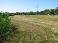
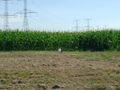
Since the park is on the edge of town, there is a cornfield adjacent to it, and right on the edge of the field was where the hashpoint lay. I was very pleased that I was able to snap a photo of the GPS exactly as the coordinates shown were lined up, accurate to the hundred-thousandths place. I planted a flag and a marker.
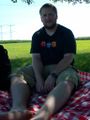
It was oppressively hot outside, so we left the hashpoint in favor of a shady spot under a tree for our picnic meal. We sat alone in the park while we had an early supper, consisting of sandwiches, fruit, Gardetto's snack mix, fruit snacks and water. I was relieved as I got off my feet, and on closer inspection I found that I had something serious going on here. At this point the blisters had upgraded from discomfort to outright pain. When I wasn't standing on them, it wasn't so much a sharp pain as it was a burning sensation, which I assume was due to the scorching they got from the hot pavement. I abandoned the plan for a game of Bocce, and instead just focused on minimizing the stress I was putting on my feet.
We finished up our meal and started limping back home. We took a different return route, which was slightly shorter in distance than the way we'd come in. Besides the Hobbit fiasco, it was a successful trip, and I've also learned a valuable lesson in blister prevention.
Photos

If only I could go back and tell my former self in this picture to put his shoes on
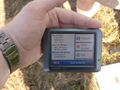
Right on the button!
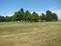
Southwood Park

The beautiful Rachel
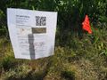
Markers...
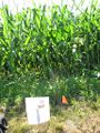
...next to the cornfield.
More of the park
The markers, seen from the our spot in the shade
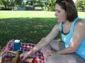
It's a pic-a-nic
Sore feet
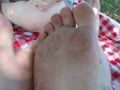
Eugh.

It's kind of hot out here!
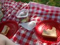
Supper contents
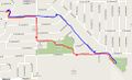
There and back again


Achievements
Dvdllr earned the Land geohash achievement
|
Dvdllr earned the Walk geohash Achievement
|
Dvdllr earned the Picnic achievement
|