2010-07-26 36 -108
| Mon 26 Jul 2010 in 36,-108: 36.6268164, -108.0344625 geohashing.info google osm bing/os kml crox |
Location
In the hills above Bloomfield a mile or so off US 550
Participants
Plans
I saw that this hash was very close to our return route home as well, so I was hopeful that we could catch it. It was fairly close to roads, so I didn't think that access would be an issue. The biggest question mark surrounding this hash was what mood we'd be in after driving pretty much all day. I knew we'd just want to get home, but I didn't think a fairly quick and easy hash would be a very big deal.
Expedition
After hitting the earlier hash in the Bullfrog graticule, we motored across the Four Corners region for most of the day. We hit US 550 around 4:30p and started looking at our options for getting east of the highway. We found a nice paved road and followed that around before finding a dirt road headed north that got me within 3/4 of a mile of the hash. We parked by a natural gas well and I surveyed the situation. I knew that I wouldn't have any trails, and I figured that I could cover the 0.7 mi fairly easily, so I told the family to stay put and headed out down the hill to find the hash. The terrain was fairly easy dirt with some pinon-juniper mixed in, but I soon realized that I'd have to dip down into some ravines to get across a few ridgelines to where the hash was. This wasn't a big deal until I realized that the ravines were filled with tamarisk, which meant that there was water in them. I got closer and found cattails, too, as well as being choked with other weeds and thistle and such. This wasn't going to be as easy as I'd hoped. The ground was literally seeping water all over the place as the high mesa gave way to the hills leading down to the San Juan River. I finally got across or avoided a few of the marshy finger ravines and stuck to the ridges as much as possible, but I eventually got to the main largest marshy area that I knew I'd have to cross. As I was going along looking for a suitable crossing spot, I suddenly found myself face-to-face with a rattlesnake in a clearing only a few feet away from me. It started rattling and I beat a hasty retreat. I was MUCH more on guard for the rest of the hike. I finally found a way across the soft ground and made my way up the dry ground on the other side to small ravine where the hash was located. I tried to head due south to avoid as much of the marshland as possible on the way back. This was largely successful, although I still had to cross at one point, and this time wasn't as successful at keeping my feet dry as I had been on my earlier crossings. Ah well. The thick brush and poking plants was really getting old at this point, and I kept heading up the ridges hoping to get to more open country out of the wetlands that fed the vegetation. I finally got to where I could navigate a little easier, then headed back across country to return to the car. Whew! So much for the quick and easy hash, but it was a successful trip after all.
The biggest irony was found when I checked the aerial maps later. If I'd just driven a little further around and tried to come at the hash from the other side it would have been a much shorter hike and totally avoided the marshy areas. Grrr. Ah well...guess the way I did it qualified me for a MNIMB achievement. :-)
Track
Track located here.
Pictures
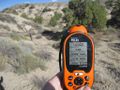
GPS coordinates
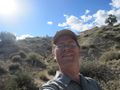
Me grinning


Achievements
redaragorn earned the Graticule Unlocked Achievement
|
redaragorn earned the One with Nature Geohash Achievement
|
Redaragorn earned the Multihash Achievement
|
Redaragorn completed the Minesweeper Geohash achievement
|