2010-09-05 42 -87
| Sun 5 Sep 2010 in 42,-87: 42.2590839, -87.8682876 geohashing.info google osm bing/os kml crox |
Contents
[hide]Location
Lake Forest, Illinois. Near the Northwestern Lake Forest Hospital
Participants
Expedition
Having been in Sudbury, ON and back home over the last few months, it had been too long since my last long cycling ride. The internet and the weather both seemed to agree, accessible coordinates in the Kenosha Graticule at ~17oC. Time to start working on my minesweeper level.
Planning to be at the point around 4pm, I packed up my panniers and my | Garmin 12 GPS. I had a large lunch of rice and sockeye salmon leftover from dinner Friday, during my mother's and sister's visit. When I realized it wasn't Saturday, I grabbed my bike. With little extra air pressure and a tap on the cotters, I started cycling up the lakefront. I took the same path as for my first attempted hash in the region, 2009-10-04_42_-87. (I can't believe I never posted this one.) Through the loop the up Elston to the North Branch Trail. I stopped by Union Station for some train schedules and at the Milwaukee & Elston McDonauld's to refill with water. I had intended to take the NB Trail up to the Skokie Valley Trail. The maps on the NB trail cut off beyond the park district, so that I missed my turn off. I ended up on the Green Bay Trail. I found my error when reaching Highland Park, and took Park street back to the Skokie trail. Here at the 70km mark, I bonked. (I really should've stopped for water in Highland Park.) I slowly made my way the hash point around 2:25pm.
I made my best guess as to the hash location, then parked and turned on the GPS. I was about a second of latitude west. I found the hash point under some oak trees along the road ROW. I took a picture back towards my bike through the trees. I found a nearby pesticide marker that would be perfectly re-appropriated as a geohash marker. Hmm, good thing I didn't lay down in the grass.
Certain that I wouldn't make it all the way back to Hyde Park, I took a look at the train schedules I picked up. A train every 2 hours on both the Milwaukee north line and the UP north line. The Milwaukee line was closer and had a train arriving at 3:10pm. I quickly rode towards the rail line. My maps did not show station locations. Instead of taking the suburban highway Waukegan Rd. south to the nearest cross street, I took the road I was on into the Middlefork Savanna preserve expecting to pick up a trail. Fortunately the trail existed. Near it's end, I passed two other cyclists for directions. I had to get back to Waukegan Rd. After getting lost down a cul-de-sac, I passed the cyclists again and made my way to the station. The station was a mile further than I had thought.
I arrived at the station and looked for the ticket machines. They're closed on Sunday, so I could buy my ticket from the conductor. Back on the platform I look at my cell phone. 3:10pm, just on time. However, the trains seem to be running late these days due to track maintenance. 15 minutes latter, the train arrived to whisk me back to Union Station.
After passing the Chicago Jazz Festival, I rode back in time to do some shopping and bathe before watching the second half of the new season of Futurama. A good day, 92km ridden. Not a cycle hash as I did not complete the return trip by bike.
Photos
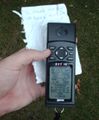
The hash.
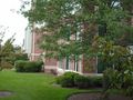
Homes behind the hash.
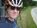
Me,
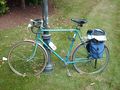
and my steed.
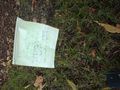
The hash marker.
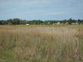
The savanna on the way to the Lake Forest train station.


Achievements
- Land Geohash