2010-09-07 49 9
| Tue 7 Sep 2010 in Würzburg: 49.6920535, 9.5039979 geohashing.info google osm bing/os kml crox |
Location
Today's location is at the edge of a forest near Külsheim.
Country: Germany; state: Baden-Württemberg (EU:DE:BW); administrative region: Stuttgart; district: Main-Tauber-Kreis
Weather: light rain ; clouded and foggy with some raindrops ; clouded ; light rain
Expedition
Danatar
Hashiversary! I had to visit this hashpoint, so after I came home from work I soon set out. I chose a route along country roads and through small villages. I took a few wrong turns by listening to the navigation system ("turn right..." *turn* "...now" *brake* *drive backwards 5 m* *follow street for another 10 m to the next intersection*), but otherwise it went okay. At one such occasion I had to turn in front of the Bronnbach monastery (in German), so I stopped and took some pictures. At another such occasion next to the last house before the hashpoint I saw two hashdogs on the street next to my car when I turned, but they were called back to the house before I could get out and pet them. I stopped the car at the last intersection before the hashpoint, because the track got worse.
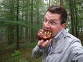
I walked the last metres towards the hashpoint when I saw a rabbit/hare running away, along the track in front of me. I followed it and found the corner of the forest with the hashpoint. It wasn't raining, but there were still raindrops falling from the trees. Soon I was doing the GPS dance until I finally was able to take a picture of the GPS receiver with the correct coordinates. Then I took pictures of Scott with the hashiversary cake. Afterwards I ate (not all of) the cake. I'm sorry, thepiguy, but I forgot you-know-what at home.
When I started to walk back to the car, shortly before I left the forest, I saw a car coming down the track. But it wasn't a geohasher (or one with bad orientation skills) and the car drove by. I drove back to Külsheim and chose a different route for the way back. My car's fuel gauge was showing "0 km range left" shortly after Külsheim, but I knew I would be able to get home. In Würzburg I stopped at the discount gas station and filled the fuel tank. When I went into the service building to pay the clerk, there were three people in front of me and the young man at the cash point was on the phone. I could hear "... it's still marked red and the customer can't pay..." "...I already restarted the system but..." and similar things. It took about 20 minutes and 4 or 5 phone calls until the customers with cash were able to pay, the ones with bank cards had to wait for the service guy. I always have enough cash with me, so I could pay and go home.
Exactly two years ago I did my first geohashing expedition (here). In the last year, my second year of geohashing, I:
- visited another 39 hashpoints (out of 44 tries) in 6 new graticules, in 3 new countries
- met 1 new geohasher
- cycled almost 300 km, walked 30 km, used public transport for 300 km and motorized vehicles for 500 km
- spent another 315 Euros for geohashing (most of that for my two GPS receivers)
Danatar earned the Second Hashiversary achievement
|
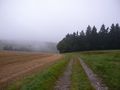
almost there
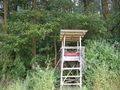
the hashpoint is behind this raised hide/hunting stand
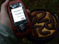
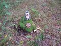
GPS and cake
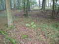
the location
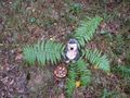
Scott with the "Second hashiversary" cake at the hashpoint
alternate hashpoint 2 metres away, with mushrooms
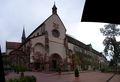
Bronnbach monastery
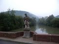
St. Nepomuk on a bridge over the Tauber at Gamburg
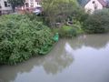
the Tauber pearl near St. Nepomuk


