2010-09-17 44 -79

| Fri 17 Sep 2010 in 44,-79: 44.9597949, -79.3629625 geohashing.info google osm bing/os kml crox |
Location
The geohash appeared on Google maps to be on a golf course, in a giant sandtrap, not far from the entrance of a golf course in the Muskoka region.
Participants
Plans
Whilst driving from Parry Sound to Toronto, we would detour along a scenic route near Gravenhurst, among the picturesque lakes that rich Torontonians call "cottage country." The plan was to find the golf course, then if it was unfenced and public we would walk onto the course for a photo session in the sandtrap. If it was private we would ask permission to do that, and consider renting clubs for a Golf Achievement.
Expedition
Wade's GPS (a.k.a. "the spontaneous adventure generator") brought us almost unerringly to the golf course (it made one attempt to take us there by someone's driveway, but to its credit the driveway did have a street name on it, and was quite close to the geohash). We pulled into the golf course parking lot and stopped the car. Before we even had a chance to discuss strategy, a young man appeared beside the car to welcome us to the Taboo Golf Resort and Spa. Robyn told him that we did not play golf, but that we would like to take some pictures of the course to show our friends. He said that he would be happy to give us a tour. Robyn explained that there were some particular coordinates she would like to visit, in what appeared to be the largest sand trap on the course. He remained enthusiastic about his ability to help us with that and ushered us into an enormous golf cart.
Now where did we want to go? Being on holiday we didn't have a printer, and the giant sandtrap had looked pretty close to the entrance. We told him the bearing and distance to the point and he started driving to where it might be. The golf course was spectacular. It was kind of a mini version of the Muskoka area, with the natural rock, vegetation and undulating terrain used to terrific effect. It's difficult to describe how ritzy the golf course and the golf cart ride were.
Riding in the golf cart we went up and down hills, around miniature mountains and over miniature rivers. This was a golf course that made me understand why people would play golf--at least why they would play on days that the geohash was not accessible. We got to where our guide estimated the big sandtrap to be, but we were further from our goal than before. We repeated this several times, each time not being anywhere near the target, until finally he realized it was probably on the driving range. A driving range sounded like some place we wouldn't be allowed to go, but that was no trouble either, and we were soon trundling up behind the driving range where there was not an enormous sandtrap, but an enormous rock. Brendon drove right up to the edge of the rock, and we took our first steps on the expedition.
We walked up the rock and as Robyn neared a puddle in its surface several frogs all leaped from the rock into the puddle, too quickly to be photographed. Meanwhile Wade had zeroed out his GPS and was laughing. Why? Because there was a golf ball sitting right on the geohash. Now it's not too surprising that there would be a golf ball on a golf course, but it was the only one we noticed on that rock. After a brief photo session we got back in the golf cart and were chauffeured right back to our car.
It was an unexpectedly unusual experience, as every geohash should be.
Photos
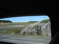
We drove along windy roads to the golf course
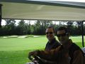
... then rode in a cart ...
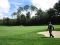
... around a ritzy golf course ...
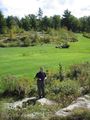
... to the geohash.


Achievements
Do you get the golf achievement ribbon if there is a golf ball already at the geohash without your intervention? We could be said to have caused its presence by the act of observation, right?