2010-10-01 52 0
| Fri 1 Oct 2010 in Cambridge: 52.1304542, 0.0668792 geohashing.info google osm bing/os kml crox |
Contents
[hide]Location
In the corner of a field just south of Harston, near Cambridge.
Participants
Expeditions
Benjw, 3:45pm
This geohash was only about 12km from my house, as the GPS flies, but after getting home from work, making some lunch and a cup of tea, then completing a few tasks round the house, I was feeling pretty exhausted and so the potential cycle hash looked increasingly unlikely. With an hour or more to kill in what remained of the afternoon, though, I thought I might as well at least drive there, seeing as it was quite close to home.
The drive took longer than planned, as rush hour had already started by 3:45pm, but I got there in the end, making a mental note to avoid the motorway on the way back. I parked on the verge of the A10, more or less opposite the gate into the field the hash was in, crossed the road, and walked the short distance along the footpath beside the road to the gate.
There I found that it was padlocked. I could see cows in the field in the distance. It was raining and I wasn't in much of a mood to spend ages trying to find the owner of the field to ask permission to walk through it, so I took a couple of photos and went home again.
On getting home, however, and looking at the overhead view on Google maps, I notice that I seem to have been looking at the wrong gate. I'm not sure how that happened. I was looking into the next field to the west of the hashpoint field, and the overhead photo clearly shows some kind of access into the field I wanted to be in a little to the east of that. But I definitely don't remember seeing it while I was there.
It's a bit mysterious and I feel a little confused, mixed with a bit cross. I'm considering going back there to check it, although that might wait until after the traffic clears now...
Benjw, 6:30pm
After I got home this one nagged at me. How could I have missed the correct gateway? So a few hours later, I dropped Mrs Benjw off at her Girl Guides meeting, then went back to the hashpoint.
This time I came prepared with the coordinates of the supposed gateway, and I saw why I had missed it the first time. Between the Google photo being taken and my visit, the hedge had been allowed to grow up again and there wasn't much of an opening left. A decrepit wooden pallet was propped in the middle, presumably to indicate that it was no longer used for vehicle access to the field. The new hedge growth was still sparse enough for a pedestrian to walk through, though, so I did.
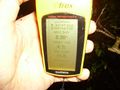
I walked along a narrow grass verge until I reached the far corner of the field. Here I discovered that Google had lied yet again. The hashpoint was not in this corner of the field; it was in or just over the hedge into the field I'd looked at a few hours ago. Happily, the bottom of the hedge was quite sparse and there was room for me to squeeze underneath. While under the hedge the GPS dropped to below the magic three-meter distance, so I didn't bother going any further. I discovered that it is quite difficult to take a good photo of a GPS while on hands and knees under a hedge. Oh, and did I mention it was raining?
After removing myself from the hedge, I decided that was quite enough fun for one day, and returned home. (The motorway was now clear, so I went around the city centre rather than through it, which saves a lot of stress and anguish.)
Photos
First expedition
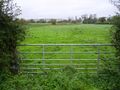
I thought it was in this field, but I was wrong.
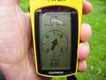
I couldn't get closer than 117m.
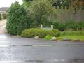
Manor Farm, on the other side of the road.


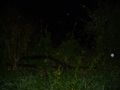
Second expedition
This was a gateway when Google was last in the area.
Success tastes sweet under a hedge in the rain.
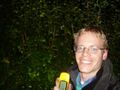
Me and my hedge, getting wet.


Achievements
Benjw earned the Land geohash achievement
|