2010-10-10 49 9
| Sun 10 Oct 2010 in Würzburg: 49.8328899, 9.9365460 geohashing.info google osm bing/os kml crox |
Location
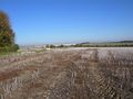
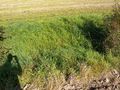
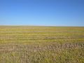
Today's location is in a stubble field north of Würzburg.
Country: Germany; state: Bayern (Bavaria, EU:DE:BY); administrative region: Unterfranken; district: Würzburg city district
Weather: Sunny all day
Participants
- friend 1
- friend A
- Danatar
afternoon expedition
It was Danatar's plan to let the others write the report, because their "new" point of view might be more interesting, but because of too much work they weren't able to do so by now.
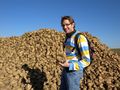
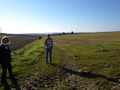
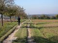
The three of them met near Danatar's place and walked up the hill on the track Danatar had taken in the morning. (Friend A) had a GPS unit, so the others just followed him, with Danatar asking "where do we have to go?" at regular intervals just to keep him focused. They followed the field tracks and enjoyed the sunshine. When they found a large pile of sugar beets, (friend A) searched for a special one to carve a Rübengeist (turnip ghost/spirit). Carving Rübengeister and putting a candle in them similar to the pumpkins on Halloween is an old tradition in some regions of Germany. But no suitable sugar beet turned up. Instead Danatar and (friend 1) tried to take bites out of sugar beets, getting their mouths full of dirt in the process.
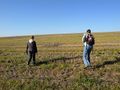
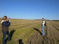
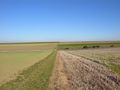
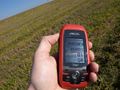
They continued and came nearer to the hashpoint. On the last track leading to the hashpoint a delivery van was parked. They could see that a guy and a girl were in the back of it but they quickly closed the door when the geohashers came nearer. They were probably working on one of the rarely achieved ribbons. (Friend A) led the way to the field the hashpoint was in, then followed his GPS unit into the field. His first GPS dance followed, and there they were.
They looked around a bit, enjoyed the sunshine and took a slightly different route back to Würzburg, including a detour through the vineyards.
(Friend 1) earned the Land geohash achievement
|
(Friend A) earned the Land geohash achievement
|
Danatar earned the Drag-along achievement
|
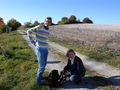
Danatar's friends
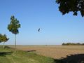
XXL kite
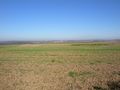
at the hashfield
almost there...
his first GPS dance: "does this mean it is here?"

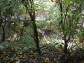
panorama at the hashpoint
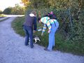
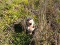
they instinctively went for the hashdog


Danatar's juggernaut expedition in the morning
I had told (friend A) and (friend 1) of the hashpoint and they were interested in going, but hadn't decided yet on Saturday. Also I saw that the route from my place to the hashpoint would be a rather straight line, so I wanted to try the juggernaut achievement. And of course I'd walk.
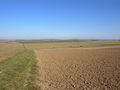
After printing a map with both the beeline and a route following the roads nearest to it, I started out at 10:30. I first climbed the hill on the Rimparer Steig path. On top of the hill my plan was to turn right for a few metres, then follow the road. But I could see that a tiny shortcut was possible between some trees, so I took that. Afterwards I walked along the field track next to the road, until it made a turn and I could see the field track I wanted to follow later in the distance. I thought "well, this field is already harvested and I'm here for the juggernaut achievement, so why am I following the track?" and cut right across the field.
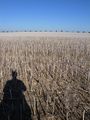
The stubbles from whatever plant there had been before were hurting my bare shins, but I continued across the next field which had the same plants. Whenever I saw an obstacle (there were two un-harvested fields) in the distance I corrected my course so I could circumvent it, but most of the time I walked in a more or less straigth line. After crossing one field and before I entered the next one, I saw a young woman with a small dog walking towards me along the path in between them. Since walking querfeldein (cross-country, but literally more like "cross-field") is not the usual way of going for a walk, I stopped and acted inconspiciously. We said "hello", but the dog was very shy and didn't come all the way to me without jumping backwards a few times. So I said "He or she seems to be an anxious one?" to which the woman replied: "Yes, she is very old." They continued along the track, and I continued to act inconspiciously until they were a bit further away, then I continued my querfeldein walk.
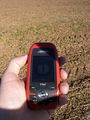
Finally when I was standing on top of a small knob I saw the hashpoint, and no obstacles in between. I set my GPS unit to "Goto geohash" and navigated using the compass screen, with "direction to destination" and the bearing arrow. At the hashpoint, the usual rituals followed.
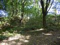
On the way back I decided I would stay nearer to the beeline, and since I knew the way now I cut across more fields. Including some more of the "my shins hurt" fields. When I came near the forest again, I decided to go right through it. Then I came to a very steep slope. I could see the track on the other side of it, so I climbed down very carefully, holding on to the trees wherever possible.
When I was walking down the last bit of the road, I received a call from (friend 1). She said one of their bikes had to be repaired first and they didn't know if they could do it, so "do you think we could walk there instead?" I confirmed that it was possible and she said they would come to me in the early afternoon, either by bike or on foot.
Juggernaut calculations:
beeline distance home-hash (blurred for privacy reasons): between 3200 and 3400 m
allowed deviation (blurred for privacy reasons): up to 160-170 m
maximal real deviation (there): 128 m (<0.039)
maximal real deviation (back): 120 m (<0.037)
shortest distance by road: ~3800 m
distance real (there): ~3470 m
distance real (back): ~3440 m
Danatar earned the Juggernaut achievement
|
first shortcut
first cross-country
right towards the ninth tree
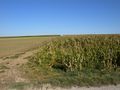
between two rows of maize
hashfield in the distance
following the arrow
across a deep roadside ditch
almost there
GPS
Coordinates reached!
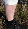
juggernaut is painful
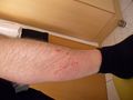
scratches were better visible later
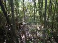
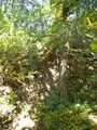
through the forest
slope from above
slope from the other side