2010-10-13 -36 174
| Wed 13 Oct 2010 in -36,174: -36.8075388, 174.7564252 geohashing.info google osm bing/os kml crox |
Location
A backyard, right next to a park, right next to the approach to the Auckland Harbour Bridge
Participants
Plans
On first looking, I thought this had landed on the motorway, thus I would have passed through it on my commute this morning. Not quite, it's in someones bushy back yard right next to a park. I'm going to make more of an effort to get to the actual coordinates, I might try the Frisbee approach. Of course, I'm going to take my kite too, but not for playing near the trees. After work today, it's all on!!!
Expedition
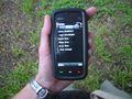
If I had been cunning, I could have timed this for a Sunset hash, but apparently I was half an hour too early. The hash was easily accessible as there was no clear definition between private and public park property (ie. no fence) hence I just rolled on up, dropped the Frisbee, and found the hash coordinates under the trees. After about 20 million photographs of my GPS device, turns out only one was clear (what's with that?).
Took some token photographs of Auckland City on a motorway overbridge. Beautiful - spot the police man.
Oh, and no wind today for the kite :(
Tracklog
Photos
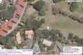
The hash map, hope i don't 'accidentally' lose my Frisbee in the trees ;)
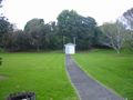
Building seen in the NE of the GMap
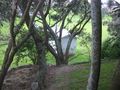
View back to that building
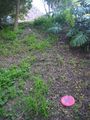
Frisbee marking the spot
Proof (if we ignore the accuracy I can say I made it)

Yup, me
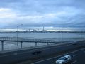
Auckland City, from a motorway overbridge


