2010-10-25 -37 175
| Mon 25 Oct 2010 in -37,175: -37.9375992, 175.1934044 geohashing.info google osm bing/os kml crox |
Location
In a paddock, not far off SH39, Te Rore
Participants
Plans
Drive there on my way back from family gathering in Hamilton
Expedition
I almost set off this morning on a mission out of my home graticule without looking at the hash, what was I thinking? Turns out there was a hash only 30 km from my destination, in a paddock not far off a main highway.
After the family brunch, I drove there, parked up, and wandered up to the farmers house and asked permission with the usual 'this is random but' rant. After a hefty conversation about everything possible, permission was obtained and I used my GPS phone to find the location. It was in a recently hoed paddock that was to be planted in maize that afternoon - good timing. Hash attained, and i wandered back to my car.
An interesting feature nearby was the Te Rore War Memorial - remembering eight local soldiers whos lives were taken in WWII. Eight trees were planted to commemorate them, which had grown into fine large specimens. In a neighbouring paddock was a Kauri tree planted in 1937 to mark the Coronation of King George VI. The view of the nearby extinct volcano - Mt Pirongia (960 m)- was superb.
Tracklog
Photos
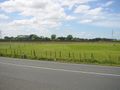
Towards the hash

Proof
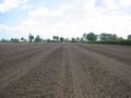
View from the hash
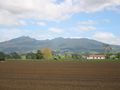
View of Mt Pirongia from the hash
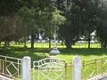
WWII memorial
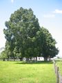
73 year old Kauri tree


Achievements
Greenslime earned the Ambassador achievement
|