2010-11-28 52 0
| Sun 28 Nov 2010 in Cambridge: 52.8809510, 0.4843471 geohashing.info google osm bing/os kml crox |
Contents
Location
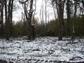
A snowy wood of beech and oak, west of Snettisham, Norfolk, UK.
Participants
Expedition
After visiting friends for a weekend of beer and curry, Sourcerer, Neil diverted a few miles north of his direct route home to take in this hashpoint. After a picnic in the Royal Sandringham woods (in the car because it was +0.5 Celsius), Neil drove to Snettisham and then went for a one hour circular walk taking in the hashpoint.
Being ageing and grey haired has its advantages. The "Private - No Public Right of Way" signs, without glasses, looked identical to the frequent "Public Footpath" signs. Neil had completed his trek to the hashpoint before realising the route was forbidden. As the paths and clearings to reach the hash looked identical to the public path and Neil met no-one on the whole walk, no harm was done. The hash was about 150 metres from the public path.
The temperature had been sub zero all day but it had warmed to +0.5C for the walk to the hashpoint so the Frozen Geohash award was just missed.
Photo Gallery
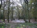
Woodland
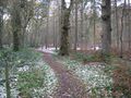
Woodland
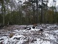
The snowy hashpoint
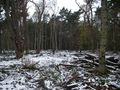
The snowy hashpoint
The snowy hashpoint
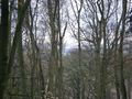
Sea view over the Wash
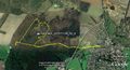
Google Earth Path


Track Log
The gps track log has been saved on Wikiloc.
Expeditions and Plans
| 2010-11-28 | ||
|---|---|---|
| Hamilton, New Zealand | Ellaruby, TunezNZ, Jonootto | Cambridge, Hamilton. In a park strip along side a housing area, Right on th... |
| Bern, Switzerland | TheOneRing, TheOneRing | | At the village of Zimmerwald there is located the Zimmerwald observatory wh... |
| Cambridge, United Kingdom | Sourcerer | A snowy wood of beech and oak, west of Snettisham, Norfolk, UK. |
| Oslo, Norway | Someone went | Nordengveien, Slependen, Oslo. In a bit of forest in a residential district... |
| Uppsala, Sweden | Someone went | About 8 km outside Uppsala, the closest by far for me since I started geoha... |
Sourcerer's Expedition Links
2010-11-21_51_1 - 2010-11-28_52_0 - 2010-12-07_52_1 - KML file download of Sourcerer's expeditions for use with Google Earth.