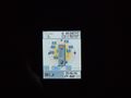
2011-03-29 49 11
| Tue 29 Mar 2011 in Nürnberg, Germany: 49.0451637, 11.9016044 geohashing.info google osm bing/os kml crox |
On a farmyard driveway, west of Deuerling.
dawidi
I had originally thought about visiting this hashpoint in the morning, before work, but of course I overslept as always. In the evening, I rather spontaneously decided to go for it on the way home. So I parked my bike near Regensburg-Prüfening railway station, bought a ticket (surprisingly, the ticket machine worked!) and got on one of the shiny, quiet, new "Agilis" trains for a short 11-minute ride to Deuerling.
In the last light of dusk (it was about 20:20 by now, half an hour or so after sunset) I followed a little footpath I had seen on satellite imagery up a hill. After a while I had to get out my flashlight, only to realize I was standing right next to a tree that had, years ago, had a geocache disguised as a nest box in it - but apparently not anymore.
The next thing I noticed was that I had gone a little farther around the hill than I meant to, so I zig-zagged back across the meadows until I found the correct trail that got me down into the valley, to an intersection near a farmyard.
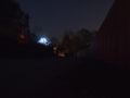
The exact coordinates were only a few meters into the farmyard's driveway past a signpost declaring it private property, but since it didn't seem like they had a dog guarding the place, I dared to go in as far as necessary to get the proof photo. Then I took a few more long-exposure photos from the nearby road, and started walking back, as I had only a little over half an hour left before the last half-hourly train.
On the way back I took the "right" trail (the one closest to the straight line between the hashpoint and the station) but it turned out to be far more boring than the wrong one, vista-wise. Nevertheless I managed to take a few more nice landscape pictures from there, and got back to the station in time. Another 11-minute train ride, and I was back in Prüfening.
Coordinates reached.
dawidi standing on the hashpoint.
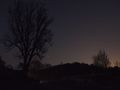
The tree overlooking the hash.
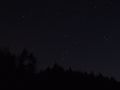
Orion, the hunter, just above the treetops.
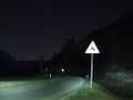
Illuminated country road.
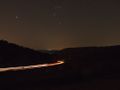
The valley's main road.
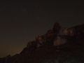
Rocks on the side of the hill I went over.
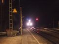
Regional train, take me home... :)


