2011-05-07 45 -122

| Sat 7 May 2011 in 45,-122: 45.4425543, -122.6903141 geohashing.info google osm bing/os kml crox |
Location
A suburban street off of Scholls Ferry Road.
Participants
Expedition
Expedition One
On the way back from a running event in Forest Grove, I let the GPS guide me around the maze of suburban streets west of Lewis and Clark College. The hashpoint was at the end of a dead end street, just where it split into private driveways. There was a landscaper's truck parked on top of it; I suppose I could have crawled underneath it if I were persnickity, but I take a practical view of these matters and declared victory instead.
Expedition Two
I headed to the hashpoint after the Farmer's market. I had a few errands to do on the way, which took up time so I didn't get there too much before the appointed 4PM hour. I parked in the street next to the aforementioned truck and a neighbor asked if she could help me. I replied that I was doing a scavenger hunt and needed a photo of the street there. She muttered something about wasting an afternoon, but seemed to regard me with suspicion when I decided to wait til 4PM to see if anyone else showed up. (I didn't see anyone.)
The hashpoint was uninspiring, being under, or behind the truck. The neighborhood was nice, and it is nice that people were keeping an eye on what was going on.
Photos
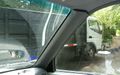
Truck atop hashpoint.
Achievements
- Land Geohash