2011-08-22 52 -0
From Geohashing
| Mon 22 Aug 2011 in Northampton: 52.7009626, -0.9826446 geohashing.info google osm bing/os kml crox |
Contents
[hide]Location
In a cattle field south of Gaddesby and north of South Croxton, Leicestershire, UK.
Participants
Expedition
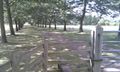
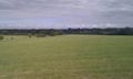
On my return journey, visiting good friends for beer and curry, I made a small diversion and took in the hashpoint about 12 km north east of Leicester. This was in beautiful farmland with mature trees and hedgerows. At the north end of the walk was a nice looking country pub, sadly closed on Mondays. My run of bad luck with hash-pubs continues!
The walk is logged at wikiloc.
Photo Gallery
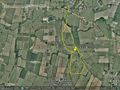
Google Earth Path Image
Beautiful Farm Land
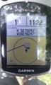
The Proof
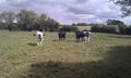
Friendly Cattle
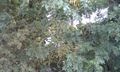
The Terrain and Nice Weather
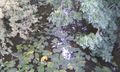
Nearby Woodland Stream
Nearby Woodland Stream


Expeditions and Plans
| 2011-08-22 | ||
|---|---|---|
| Atlanta, Georgia | NWoodruff | On a back lot of land west of Forsyth |
| Scranton, Pennsylvania | Jevanyn | It does not look like it's private, but I've been wrong before. |
| Fond du Lac, Wisconsin | RocketMac | The yard outside "Sunrise Apartments" senior living center. |
| Madison, Wisconsin | RocketMac | The parking lot of a Piggly Wiggly store. |
| Marshfield, Wisconsin | RocketMac | Private property in the middle of a rural area where property lines were ha... |
| St. Paul NE, Minnesota | RocketMac | A stretch of rolling green and woods on a private farmland. |
| Minneapolis NW, Minnesota | RocketMac | The edge of someone's house. |
| Pforzheim, Germany | Ekorren | Sindelfingen, in a parking house of the Daimler-Benz (Mercedes) factory. Du... |
| Northampton, United Kingdom | Sourcerer | In a cattle field south of Gaddesby and north of South Croxton, Leicestersh... |
Sourcerer's Expedition Links
2011-08-16 52 1 - 2011-08-22 52 -0 - 2011-09-17 52 0 - KML file download of Sourcerer's expeditions for use with Google Earth.