2011-09-04 38 -74
From Geohashing
| Sun 4 Sep 2011 in 38,-74: 38.9459927, -74.9576861 geohashing.info google osm bing/os kml crox |
Location
750 yards north of Sunset Blvd., West Cape May
Participants
Plans
- Sneak out of the house in the morning and get back before I'm missed.
- Jevanyn: I happen to be staying in Cape May this weekend, I'll have to see how close I can get on foot, but it's way off the road into swampy territory.
Expedition
- Didn't make it, the geohash is in the swamps behind a private farm.
- User:Jevanyn: This spot might be reachable, but I suspect it's actually swamp/wetland. I'll try to scout it out. It's less than a mile from where we're staying, and it looks like there's a path, but satellite photos can be deceiving. -- Jevanyn @38.9403,-74.9528 09:40, 02 September 2011 (EDT)
- I'd love to capture the flag in this graticule, but I'm not getting any closer without a machete. -- Jevanyn @38.9435,-74.9565 08:27, 04 September 2011 (EDT)
Tracklog
Photos
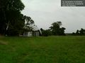
A geodesic farmhouse, abandoned? @38.9435,-74.9565
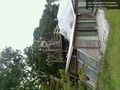
That's some deck.... @38.9432,-74.9565


Achievements
- There might be gators?