2011-09-04 49 9
| Sun 4 Sep 2011 in Würzburg: 49.9459927, 9.9576861 geohashing.info google osm bing/os kml crox |
Location
Today's location is in the Gramschatzer Wald forest north of Gramschatz.
Country: Germany; state: Bayern (Bavaria, EU:DE:BY); administrative region: Unterfranken; district: Main-Spessart
Expedition
Danatar
It’s Danatar’s birthday again, i.e. a day where visiting the hashpoint was absolutely important. The party had been in the evening before, then there was a little breakfast in the morning, but the rest of the day was not occupied. After breakfast, it was already very hot, so I postponed the expedition, which would include some very steep hills, to the afternoon. The only other activity for the day was to bake birthday cakes for my colleagues for the following day. I started a little late with that, so I could leave only after the second cake was out of the oven, around _____. The day’s heat had already subsided but it was still sticky outside and there was around 1 raindrop per minute. I cycled one the usual path to Versbach and to Rimpar. At Rimpar, the steepest part of the journey made me push my bike because it was just too difficult to cycle uphill in that weather. Along the state road I continued to Gramschatz and beyond. The raindrops started to come more often, about 5-10 per minute. At the forest north of Gramschatz I turned from the main road to a forest path which was leading straight through the forest towards the hashpoint.
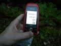
When I was near the spot I left the bike on the track and continued on foot into the underbrush. Although I had the GPS unit to show me the direction towards my goal, I was zig-zagging around for a while, even walking away from the hashpoint at one time. But finally I reached a spot where the trees were a little bit further apart and the GPS receiver declared ‘coordinates reached’ around 19:55. It was finally raining by that time and getting darker by the minute, but I took the celebratory pictures and went to eat the tiny birthday cake I had made especially for geohashing. It was in a battered state after the journey in a bag on my bicycle, but it tasted wonderfully. With the aid of my compass, I went back straight south to my bike.
While I was cycling back to Gramschatz, it was still raining and it was finally quite dark. I didn’t feel like cycling on a state road through the forest in the rain and in darkness with only my weak bike light. So I decided to take a taxi and stopped at the side of the road. The taxi center phone number wasn’t in my mobile phone any more and number I had memorized for the directory assistance was wrong, so I called a friend whe gave me the correct number for the taxi service. I told them to fetch me at the church in Gramschatz, because I could see that from where I was and they told me it would take about 20-25 minutes. Then I continued the last kilometre to the church, parked my car and waited. The taxi arrived around 20:40 and brought me home. The driver saw my bike helmet and asked if I had been by bike and I told him something about a little bike tour which had been delayed until dusk, I didn’t say anything about hashpoints.
Danatar earned the Birthday Geohash Achievement
|
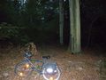
Not far now
GPS
Coordinates reached!

looking much older suddenly
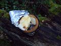
The vanilla pudding has shifted, showing the pear and the poppy seed beneath
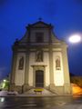
Gramschatz church


