2011-09-11 57 -2
| Sun 11 Sep 2011 in Aberdeen: 57.3321399, -2.9189641 geohashing.info google osm bing/os kml crox |
Contents
[hide]About
Smoulder and Damianc made this expedition.

Expedition
Drove 38 miles from home and parked at the entrance to a Forestry Commission track, ignoring the Warning: logging sign as it was Sunday. Walked along the track to the base of the hill, disturbing a female red deer along the way.
The base of the hill was planted with young firs which were rather dense, so we contoured northwards until we had to strike up the hill to get to the hash point. We were lucky to find a thinner bit of forest and reached the hill easily, only having to navigate the greater wood rushes. Thereafter it was a case of overcoming the heather as well as the increasing altitude and then a bit more stumbling around on the slope to find the hash point. This was remarkably easy with the GPS app on the phone.
There was growing a magnificent heather plant right on the hash point, the best specimen we'd seen on the hill. We sat above it and surveyed the view with our cups of tea. Damian stood on a nearby boulder for a birthday pose and we marked the spot on the nearest rock, six feet away.
On the way back, through the rotting debris from a previous forest clearance, Smoulder saw a mouse running between two parallel logs. She had never before seen a mouse in the field, so to speak. And we picked the few bilberries remaining.
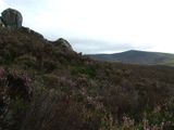
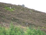
We also took in the rocky knolls to the north of the hash point: more heather plus broom and tufty grass. And then we found a pleasant avenue through the larches back to the track.
As we drove away, we found a good viewpoint of Turf Hill. We had a good time there.
Achievements
damianc earned the Birthday Geohash Achievement
|
damianc and smoulder earned the Land geohash achievement
|
Photographs
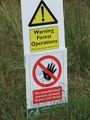
Obey ALL signs!!

Obey
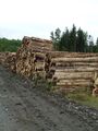
The log pile, keeping away from this! Smells nice though
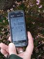
Proof!
We left a biodegrable record (graphite)

damianc; close to being blown away
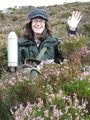
Best drink of the day; As seen over heather plant on the hash point (Calluna vulgaris)

North West view showing rocky knolls
Western view
Hash point


