2011-09-17 49 9
| Sat 17 Sep 2011 in Würzburg: 49.7586070, 9.8922134 geohashing.info google osm bing/os kml crox |
Location
Today's location is in the Steinbachtal forest at Würzburg.
Country: Germany; state: Bayern (Bavaria, EU:DE:BY); administrative region: Unterfranken; district: Würzburg city district.
Expedition
Danatar
It was a Saturday and the hashpoint was inside the Würzburg city limits, so I jumped on my bike for a quick expedition. I cycled to the Main river and crossed it on the little bridge directly at the entrance to the Steinbachtal valley. Then I followed the street until I reached the place where multiple forest tracks start. I entered the coordinates into the GPS receiver and it told me I had about one kilometer to go. The cycling along the forest track up the hills went okay this time, and after one kilometer I looked at my GPS unit so see how far I had to go. WHAT?! WRONG AGAIN!? As during the 2010-05-25 49 9 expedition I had taken the wrong forest track. Like that time, I followed the tracks indicated on my map that pointed in the correct direction. It worked and I left my bike on the forest track while climbing the hill on a small logging path towards the hashpoint. There were signs of wild boar activity and I hoped to not meet any. At 15:55 I was near the hashpoint, went the last metres straight through the underbrush and did my little GPS dance. This time I had nibs with me, but no chalk for marking the trees.
Then I went back down the hill on another logging trail that went right past the hashpoint. When I was only a few metres from the forest track I heard female voices talking in an eastern European language. For a split second I thought about jumping out in front of them with a wild scream, but decided against it because 1) I hadn't seen them or how many they might be, or if there were any bodybuilding male friends with them 2) I didn't want to be responsible for heart attacks and 3) this would look very very very creepy and I'm sure it would get me in deep sh**. So I just walked out of forest (with much cracking of twigs) about 10 metres in front of them, gave them a formal 'Good Day' and a nod of my head, turned and went to my bike which was about 20 metres away. I don't know what they thought about my appearance, but I held my camera in a way that the must have seen it and I didn't carry any toilet paper with me. They continued walking without a pause and passed me while I was unlocking my bike. Then I followed the track in the other direction to find out where it came from. While doing so, I recognized a track intersection from the 2010-05-25 49 9 expedition (at 49.7565° 9.884°, see the second picture on that page) and soon I was rolling down the hill and back home.
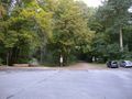
I took the left track
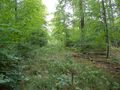
logging path to the hashpoint
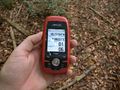
GPS
Scott at the hashpoint

panorama
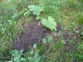
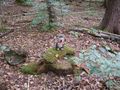
the ground has been plowed by wild boars
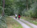
the women I met near the hashpoint


