2011-09-27 -36 174
| Tue 27 Sep 2011 in -36,174: -36.6502243, 174.5930110 geohashing.info google osm bing/os kml crox |
Location
Paddock in Dairy Flat, Auckland, New Zealand
Participants
- Greenslime
- Li'll Homie
Plans
Off for a trail run in Okura, hash location is pretty much near by. Hull road is marked on Google Maps, but not on my GPS. On closer inspection, it looks like a farm road so this may be a no go, but Ill work up a Hash appetite on my 1 hour run before hand.
Expedition
Hull road was sealed for about 200 m, and then turned into a dirt track up a steep hill. I saw no evidence of Private Property signage however it had that private property feel about it. Despite this, I encouraged my car up the hill. Got to the top of the hill and the track degraded rapidly. Umm and aahed for a wee bit, still feeling a little uneasy about being there, but decided to take the rest on foot as was only 800 m away.
The track was trail running heaven! Muddy, uneven ankle breaking stuff, with gorse bushes and cutty grass thrown in, all the stuff trail runners love! Having just run 1 hour in mud heaven, I was still up for more so bolted the track to a closed (not locked gate) and still no signage. Vaulted the gate and wandered into a farm with electric fences, water troughs and the works! Feeling very noticeable in my bright blue top, I jogged rapidly to the hash point which was just off the farm track (which i thought was a road in the satellite imagery), fumbled unsuccessfully to capture coordinates with my camera, and bolted back. In all this, I forgot to let Li'll Homie out of the car. Took a pic of him anyway looking in the general direction of the hash point.
Photos
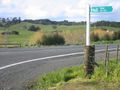
Hull Rd, ends up as a farm track
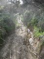
Running action along the farm track
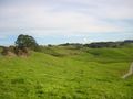
A view from the hash, farmland
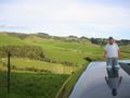
Li'll Homie came along for a ride in the car


Achievements
- Land Geohash