2011-10-12 53 -1
| Wed 12 Oct 2011 in 53,-1: 53.2873016, -1.8239939 geohashing.info google osm bing/os kml crox |
Location
On the edge of a lane near Dale Head Farm, in the Peak District parish of Wormhill. Located on the western side of Dale Head, a spot in the upper reaches of the series of Dales through which the Limestone Way passes through.
Participants
Plans
With a late-morning appointment already disrupting the normal day, opportunity was taken to drive out from Sheffield, eventually against (and thus unhindered by) a large amount of commuter traffic out along the A625 down over Froggat Edge, through Stoney Middleton on the A623 and thence through Tideswell to Wheston and beyond to Dale Head at the point between Hay Dale and Peter's Dale. Almost up until the approach to Tideswell, this would be much the same route as taken during the morning of the 2011-10-09 53 -1 trip to get to the (non-expeditionary) destination of Monsal Head, but would mean continuing westward (and departing from the NW-heading A-road onto more minor routes) past the previously taken southerly turn-off towards Monsal Dale. Once completed, it was not envisaged that anything other than a return to Sheffield would be undertaken to the aforementioned appointment, tempting as it might be to wander off elsewhere.
Expedition
A wet morning in Sheffield did not bode well for the journey, but with no non-driving elements to the trip this was of no concern. Snow might have been a considering factor, later in the year or early into the next, but (even without consulting a recent forecast) this was never going to be an issue upon this day.
Outward from Sheffield, the few commuters from the Peak District would not cause issues for the outward trip, but to reach the outward point meant (in this particular case) joining the daily migration in from the Northern reaches of Sheffield, forcing the passing by Hillsborough at about 8AM and up towards the main concentration of University buildings in relatively slow-moving commuter traffic (for most of the way, sat behind a tractor, of all things). Heading out towards, through and past Eccleshall (not to be confused with Ecclesfield, in a different part of Sheffield, although historically both were named for their being church lands, I was once told), the weather surprisingly cleared up. Surprising for yours truly, but doubtless this impression would have been known with a judicious check of various localised weather forecasts.
Most of the route was an uneventful trip. Radio 4 cut off a bit in the upper Middleton Dale (but then it always does, there, and it's still the best signal you can get on that stretch), and there were some temporary lights on the southern entry into Tideswell (named as "Cathedral Of The Peaks") having taken the Litton turn-off. The road after Wheston was particularly narrow (and marked "not for long vehicles"), but quickly led down into the dale bottom (called "Dale Head") and back up past the farm.
Stopping on the narrow lane, the car was exited and the Google Streetview map was primarily used to find the location against easily recognisable features. Everything was nicely lined up when the sounds of a diesel engine echoed up the valley. Looking round, a milk tanker could be seen leaving Dale Head Farm's entrance and coming up the road. The car taking up most of the road, and the verge not looking like it was particularly conducive to a heavy vehicle (to be fair, sodden as it was, I wasn't too happy to take the car onto it, either) a leap was made back into the driving seat, and vehicular progress was made up to the next field gateway, where slightly firmer ground looked like a better place for the lorry to pass. (To my mind, I never noticed the lorry actually giving quarter, as it slowly accelerated up the lane, but being quick off the mark and so obviously moving the car there was probably no need.)
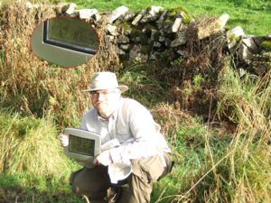
Taking the opportunity to turn around, it was a short coast back down the lane, and the features of reality and image were re-assessed. A quick photo was taken. The now quite bright morning sunshine was reflecting off the paper, causing some problems with the relative exposure levels, but at least giving a deep enough depth of field to get unblurred background even while focussed on the arms-length held paper. The worst problem with that shot was the breeze flapping the paper, which had to be effectively clamped and folded into an OS map to make it stiff enough. Memo to self: next time consider bringing a clipboard and an extra crocodile clip. And work out a way to hold it even further from the camera... Perhaps some way of attatching the mounted image upon the tripod, prior to using it to hold the camera for the self-shot.
Anyway, best of a bad job done, brightness/exposure problems did somewhat affect the self-shot, too, to only marginally better effect. But, that sorted, the return was made to the Sheffield, leaving behind the bright sunshine and reacquainting oneself with the overcast and drizzly skies that still pervaded over Sheffield by about 10am. The rest of the day was all rather more mundane and consisted of all the non-recreational activities that the rest of the world demands of your author, thus utterly not worth mentioning.
Tracklog
No track. No GPS.
Photos
-->
Achievements
TBA. Land Geohash and No Batteries alone, I think.


