2011-10-16 -37 145

| Sun 16 Oct 2011 in -37,145: -37.5873205, 145.3561470 geohashing.info google osm bing/os kml crox |
Location
In thick scrub 200m south of a walking track in Kinglake National Park, which was completely obliterated in the 2009 bushfires.
Participants
Video
Expedition
I was planning a 100km fitness ride this weekend, and checked out a possible geohash. 50km from my house? Game on! I followed the standard preparation, going to bed at 3am the night before, and forcing myself out of bed at 8:30am. tAlex was a possible companion, but preferred sleeping.
My plan was pretty simple: ride from home, up through the hills (Warrandyte, Kangaroo Ground, Panton Hill, Smiths Creek) to Kinglake National Park, then through the park on fire trail. A walking track would get me closer to the geohash - but might not be passable on bike. Then I'd continue the loop down through Yarra Glen, Lilydale, and back home by 5 for a family dinner.
All went swimmingly, except for a slowish start - didn't leave the house till 9:45. I performed an excellent high-speed bakery stop in Warrandyte, then couldn't resist another in Kangaroo Ground. Soon my minimal carrying capacity was exploding with bakery goods. The traffic was light, the roads high quality, and I was making good time. The weather spasmodically fluctuated between sunny, threatening, drizzly and rainy. The jacket came off, the jacket went on, the cycle repeated.
Once I arrived at the national park, a sudden moment of truth hit me - I had no idea if bikes were allowed in. On the sign, I could make out the word "bicycles" and my heart stopped - but needlessly. Bikes, pedestrians and horses were all a-ok with park management. I powered up Mt Everard Track, feeling strong. A couple of downhills were a lot of fun - little erosion barriers turned into excellent jumps. On I climbed, cheered on by a resting group of geriatric bushwalkers. Soon I was looking for the elusive Bundy Track - my OpenStreetMap map on the GPS was slightly out of sync with reality.
But eventually there it was - the sign had been burnt out, and the track was quite overgrown. It seems it hasn't been maintained since the bushfires. Riding along it was quite challenging - the surface was solid, but many shrubs were growing along the path, and there were plenty of fallen branches to negotiate. Somehow I managed to keep pushing through, getting progressively wetter as I pushed through the undergrowth.
The track took a sudden left turn down a steep ridge, and I belatedly realised what I'd signed up for. This was STEEP. Steep, slippery, overgrown, covered with fallen branches and loose rocks. Seriously challenging stuff on my cyclocross bike. But I had a deadline, so no time for pussy footing around. Down I went, treading a fine line between speed and recklessness.
Before long I arrived at the apogee. I ditched the bike, remembering to GPS mark its location (very important!!), but forgetting to bring my phone - a potentially costly mistake. 200m off the track doesn't sound far until you look down into a steep gully, covered with thick, wet, scratchy bushes. Yuck. I was tempted to abandon immediately and get back to the fun stuff, but memories of another failed geohash a couple of years ago haunted me. I hardened the Felix up and plunged down through the bush.
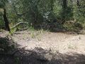
So engrossed in my psychological battles was I that I didn't notice that I was going off track. I'd just assumed I'd be going straight downhill, but it wasn't quite like that. I meandered around, slipped, sloshed, got completely soaked and scratched, as the GPS slowly counted down from 210m, to 205, to 200, to 195...it felt like a long time. Eventually the bush thinned out a bit, and I made quicker progress. Then suddenly I was at the site - a somewhat incongruous clearing. "Bip" said the GPS. "You've made it, son, well done." I took a couple of photos and started scrambling back up the slope.
It turns out that I was a bit careless and the photos are a bit off the exact geohash point. Me, I consider the geohash to be a place defined by coordinates (rather than the coordinates themselves), so I don't get too fussed. I was in the right place - I just don't get a lot of joy out of stumbling around aimlessly trying to get the GPS to sign off on my paperwork. Anyway.
Reaching the bike again (and relieved to have found it), I pushed on down the hill, and was soon out of the national park. A miserable headwind battered me through the Yarra Valley (on a hideous, narrow, busy road). My original plan was to ride all the way home, but with family commitments pressing, I took the train option.
Tracklog
http://app.strava.com/activities/1990165

Photos
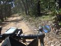
Heading up Mt Everard Track.
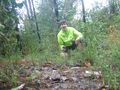
Hi-vis helps other potential geohashers to find you at the site.
Rediscovering your transport in the bush brings great peace of mind.
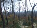
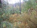
Eerie vistas two and a half years on from the tragic bushfires.
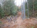
I'm not sure what this burnt out relic at the start of Bundy Track used to be.
This delightful scratchy shrub makes bush bashing so much fun.
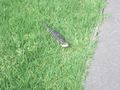
A bluetongue lizard.


Achievements
This user earned the Bicycle geohash achievement
|
This user earned the Consecutive geohash achievement
|
This user earned the Massive Climb achievement
|