2011-11-20 49 11
| Sun 20 Nov 2011 in Nürnberg, Germany: 49.2202491, 11.9939718 geohashing.info google osm bing/os kml crox |
In a forest about 5km northwest of Burglengenfeld.
dawidi
... went there at about 11 in the morning, on his way to visiting friends in Amberg. He took the train from Regensburg to Maxhütte-Haidhof (where he had never set foot before), then cycled westwards, through light rain and Burglengenfeld. The forest paths around the hashpoint were significantly worse, and far more overgrown than satellite imagery (or OSM) suggested, so it took him a while to get to the exact spot, and to half push, half carry his bike to the next usable track. The rest of the way, via Rieden and along the Vils river valley on a converted railroad track, once again took about an hour and a half longer than expected, before he got to Amberg for a rather late lunch.
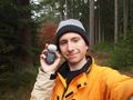
dawidi in the forest.
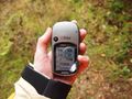
Coordinates reached.
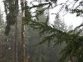
Wet twigs at the hash.


