2011-12-08 40 -74
| Thu 8 Dec 2011 in 40,-74: 40.5865754, -74.5954714 geohashing.info google osm bing/os kml crox |
Location
Peter Pan Park, Somerville/Bridgewater
Participants
Plans
- That's walking distance from my house, and it's more or less in a park to boot! If I don't take a shot at this, you can revoke my geohasher's license. -- Jevanyn 13:00, 08 December 2011 (EST)
- I have plans in the evening, I will have to get up there after 8PM.
- I have an errand to run nearby the hash this afternoon, so I will attempt to give this a shot. Google Earth does not show any 'formal' entrance signage to the park from either Vogt Drive, which is to the East or Knollwood Drive, which is North. spindizzy 15:09, 08 December 2011 (EST)
Expedition
spindizzy
Got to the hash around 15:00 EST. Approach from Vogt Drive was not practical. The actual park entrance is at the end of Peter Par Road where there were two unpaved parking spaces. Good thing I thought to wear my Sorel boots because the park was a mudfest, topped off with a heavy garnish of wet, slippery leaves. Had to be careful where I stepped because I could feel my boots sucking into the mud and I did not want to fall into the slop.
Followed my GPS indications, but I couldn't stand on the exact hash because it appeared to be on the other side of a small stream that was surrounded by a machete-worthy thicket of spiny bushes. I took some photos and left a marker impaled on one of the bushes...the needles came in handy. Will figure out if I was close enough and post photos later. Yep, close enough!
Tried to Google Peter Par to find out what his significance is, but nothing seemed to jump out as being relevant.
Jevanyn
I got to the park at about 8PM. After all the rain, it was a wet sloshy mess, and unlike spindizzy, I forgot to change my shoes. If I'd gotten there during the day, I might have had second thoughts about traipsing around in the mud.
Being there in the dark turned out not to be a big deal. There was plenty of light from the full moon, with no leaves left on the trees.
My directions were to walk downhill toward the stream that I knew was out there but couldn't see. I looked back over my shoulder every so often to keep my bearings & make sure I could find my way back out. Lights from neighboring houses gave me plenty of markers for the path out, so I pressed on.
The closer I got to the stream, however, the sloppier the footing got. I was within about 50 feet (inside the margin of error according to the Android app), and I heard the stream not far off. I did not know that spindizzy had been there earlier, so I didn't know to look for a marker. (Gotta go back Saturday :-) )
On the way out, I didn't have sight of where I'd parked the car, and ended up crossing someone's backyard on the way to the street. The "park" area before the woods is tiny, and I mistook the clear area with the basketball backboard in it as being part of the park.
- Jevanyn: I went back Saturday morning to see if I could get back out to find Spindizzy's marker, but it was still too muddy. I did find my cell phone clip, which I had dropped Thursday night without noticing, so it's a good thing I went back!
Photos
spindizzy
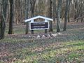
Park entrance sign
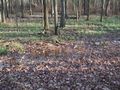
Squishy
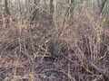
Spiny sharp things with a stream behind them
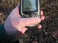
Close enough...
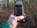
Coordinates
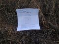
Impaled marker
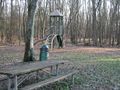
Recreation and dining facilities


Jevanyn
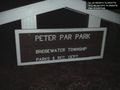
Actually, it's Peter PAR Park. @40.5873,-74.5966

Silly grin, check @40.5867,-74.5957


Achievements
Spindizzy earned the Land geohash achievement
|