2012-01-02 51 4

| Mon 2 Jan 2012 in 51,4: 51.6283017, 4.8654298 geohashing.info google osm bing/os kml crox |
Location
In the town of Oosterhout, at the side of a road. Seems easily reachable.
Participants
Plans
The weather is clearing up and it's about 15 km cycling one-way. However I'm not able to leave right now, maybe I can go later this afternoon. Alright, I will be leaving soon.
Expedition
As I said in the plans, the weather was quite good today. It got sunny although there were still a few clouds. When I left, I got a bit of rain and a lot of headwind, so like usual I felt crazy to go to a random place in the middle of nowhere just to take some pics to upload here :P.
Anyway, I went on, passing the town of 's Gravenmoer on the way. (Dare for bonus points for any non-Dutch geohashers: Try to pronounce the name of this town right. More info on the talk page.). The road was mostly straightforward, but I used the GPS to find my way in the end. The slightly less than 15 km took me slightly less than an hour.
In the end I came to the town of Oosterhout in which the hashpoint was located. Oosterhout means "Eastern wood" which is weird because it's to the West and there's not much wood there. I reached the point with both Sir Sol and Lady Luna watching over me, it was easy to find. I took most of the pics there and uniquely got an exactly right GPS coords fix. I quickly attached the marker while the batteries of my camera were starting to fail, picked up that bottle (yay geotrash achievement) and went back the same way I came. The route I took there was probably the quickest route so I took it again going back, only this time the wind was on my side so it took me only just over 30 minutes. I threw the bottle in a litter bin along the way and was home before dark.
Photos
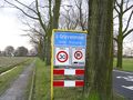
Town sign of 's Gravenmoer.
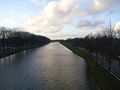
The canal I crossed just before the hash.
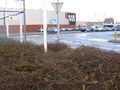
This is at the hashpoint. The exact point is at the lower right.
There was a bus terminal here.
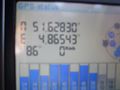
I must've had very good reception or a lot of luck. This is the first time I managed to get the coordinates on my GPS exactly right. Usually it either over- or undershoots when I walk back and forth.
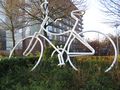
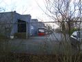
Was this the picture of my means of transport? No, it was actually a sculpture about 100m from the hashpoint.
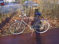
The old bike I borrowed for this hash. See the bottle on the ground just over the front wheel? I picked that up and threw it in a litter bin on my way back.
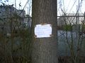
The home-made marker, similar to the other 51,4 marker I used. I put it at a well visible place next to a cycling path that looked like it is rather well travelled.


Achievements
CO2 earned the GeoTrash Geohash Achievement
|