2012-01-26 49 12
| Thu 26 Jan 2012 in Regensburg, Germany: 49.0763577, 12.0874229 geohashing.info google osm bing/os kml crox |
At the edge of a forest near Lorenzen, about 10 km north of Regensburg.
dawidi and mojibake ...
... went there by bike in the evening, around 21:00 - mostly because this was a nice opportunity to try out mojibake's new bike lights. Temperature was well below freezing thanks to a clear night sky, and they barely saw any other people as they cycled along the river Regen.
When they reached Lorenzen, they stopped to take pictures of the crescent moon setting, but resumed cycling quickly because they were getting cold. Getting to the hashpoint turned out to be a bit tricky, as the route that had seemed most obvious on satellite imagery was blocked by partially frozen puddles and a small stream between meadows, and the next option would have meant to carry their bikes over a field at the edge of a private property. They finally succeeded by going around the residential area into the forest, and then approaching the coordinates on a forest track from a northwesterly direction.
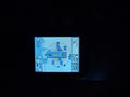
mojibake did the GPS dance and they decided that the "exact spot" would be a tree stump cut off at about a knee's height - which was useful because it could be used as a tripod. A couple of long exposures later, they abandoned the hashpoint and stood just outside the forest to drink some tea. Pushing their bikes back up into the forest provided some additional warmth, but they got pretty cold again during the 20-minute ride back into town, where they had dinner at a restaurant before going home.
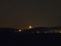
Moonset
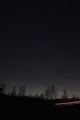
Vertical panorama of Orion over the Autobahn.
Coordinates reached.
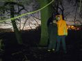
mojibake and dawidi near the coordinates
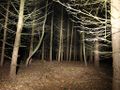
View north into the forest.
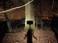
Shadow self-portrait of the camera on the hash stump.
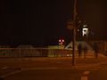
Back in Regensburg: this house... is not your father.


